Thursday 30 November 2017

Otago Central Railway [30D]: Galloway updated


Not major changes, but at least we do have a map like all the others. Next to look at will be Alexandra.

Wednesday 29 November 2017

Monday 27 November 2017

Otago Central Railway [52]: Article writing etc

So for the moment the maps focus has shifted to article writing having done most aerials, however I have decided to do aerials for Alexandra and Clyde but they will have a lower priority than completing Part 2 of the articles, so I am not how long it will take to do them. Some more research has been undertaken on the private sidings at Alexandra and the Clyde-Cromwell section of the railway.  

Some help from the Alexandra Museum has determined where Vacuum Oil and Borthwicks / Molyneaux Freezing Co were located and the provisional updated map for this area is shown below. This map is still getting tidied up and some details will probably change somewhat over the next day or two.


As at this stage no new aerial photos have been located for Alexandra to Ranfurly so the lower quality coverage for Ida Valley, Auripo and Ranfurly will have to suffice for now. In all three cases it just means the maps will have to have disclaimer labels put on them to say the exact layout is unconfirmed. Ranfurly and Ida Valley were both quite extensive stations in their heyday whereas Auripo was never very big with just one siding and a loading bank apart from the station, which may or may not have had a passenger platform. 

Friday 24 November 2017

Otago Central Railway [29C]: Chatto Creek update

Quick update of Chatto Creek with new aerial photo.
 Overall view of the yard excluding the ballast pit.
Close up of some of the facilities, the station building was off centred from the platform which is unusual. There was a water tank supplied by a race from the nearby creek, also it appears a trolley shed.

Previous Chatto Creek article

Thursday 23 November 2017

Otago Central Railway [26B]: Auripo aerials

As I mentioned before, Auripo is one area we haven't got good enough aerials of at the moment.

These two pictures are lower quality aerials from 1976 and 1982.

In this 1976 view we can see the shelter shed opposite the access road. Given what we now know about the placement of the 161 km peg there is some question over the stated station location 161.07 km which is 70 metres west of where the shed is shown - assuming the 161 km peg as it can be seen on Google Maps is authentic. It is possible of course that the centre of station limits, another measure of station location, is actually 161.07 while the shelter shed may not have been exactly in the middle. There is a suggestion that the station had a platform at one time but it is not seen in the D&E photo. A site of the loading bank is just visible and I will update the map to show these new locations.

This one from 1982 suggests post closure the loop track was left in the ground and just disconnected at either end. When I travelled up the line in 1987 and 1989 the disconnected sidings could be seen at a number of closed stations. There is probably enough detail between these two photos to reasonably confirm the station layout for the maps to be finished.

Otago Central Railway [24B]: Oturehua update

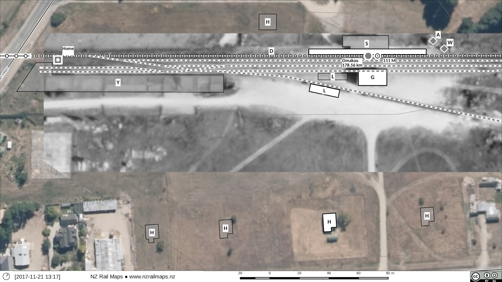
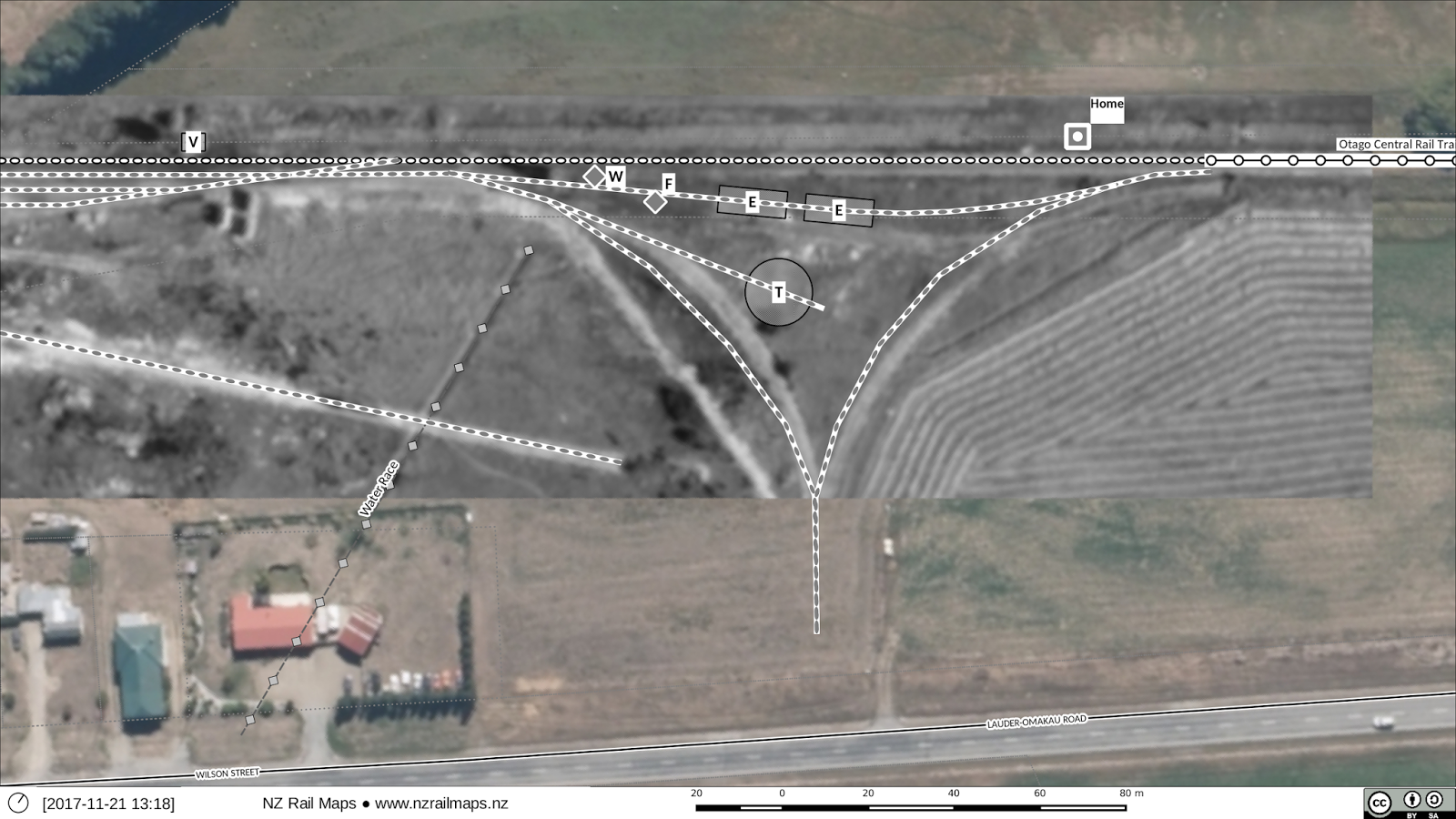
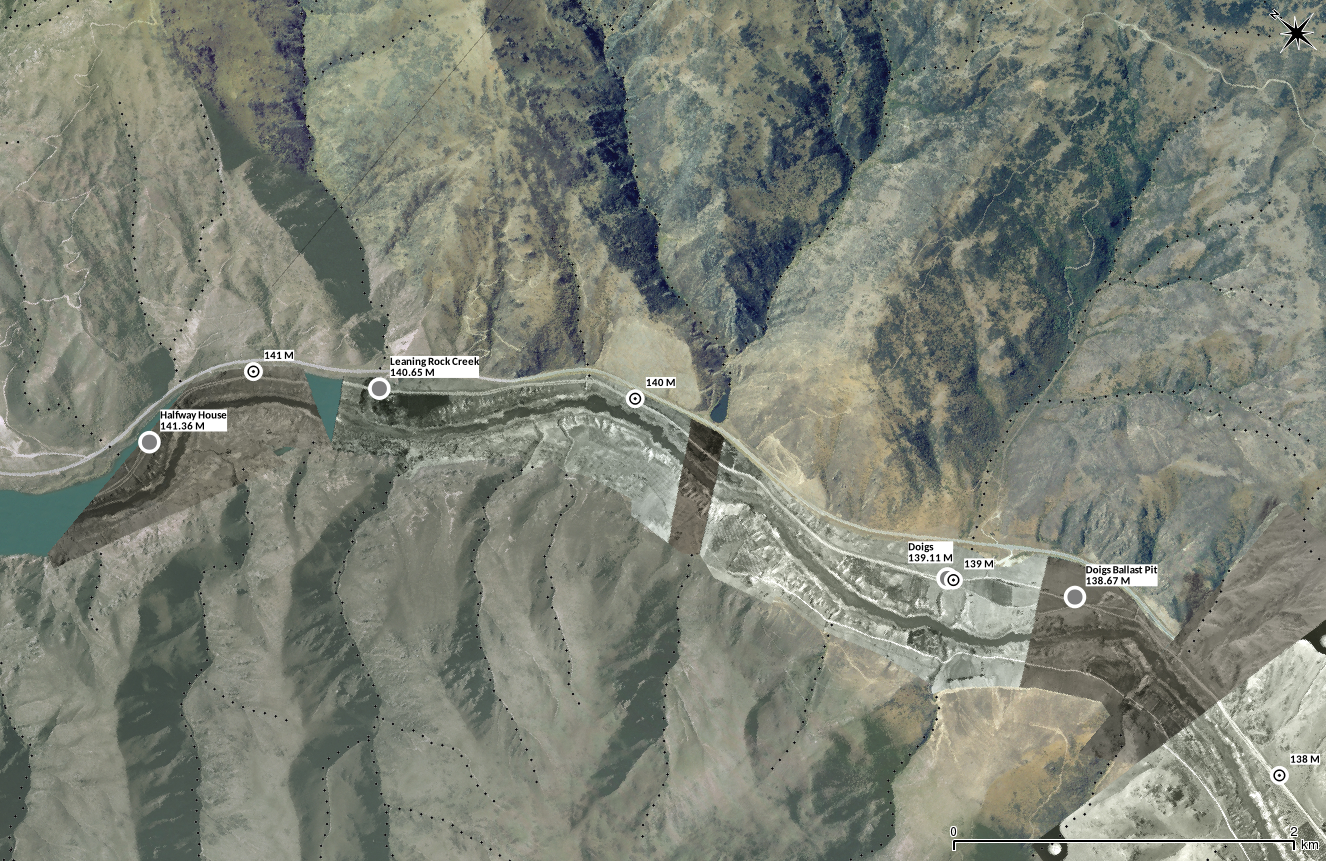
Here is the updated map of Oturehua. This map was like many earlier ones of smaller stations, drawn from chainage charts which whilst proving reasonably accurate, have not always been up to date with later changes to yards. Hence this one does show some detail variation, although not major, from the maps I drew back in June.

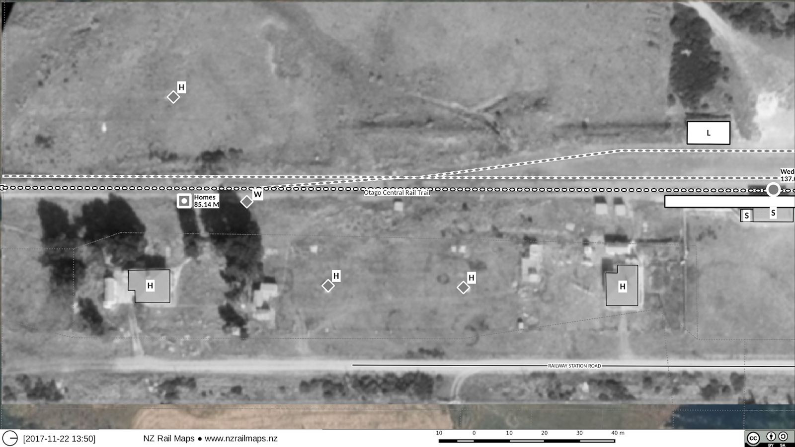
Oturehua was an average medium use yard for the Otago Central line: it had a passenger platform, leanto station building, goods shed, stock yards and loading bank. The aerial photo used to produce this map dates from 1982 and makes it difficult to verify all the details. So far, earlier photography has not been obtained.

Since closure the yard space has been turned into a transport yard. The main entrance passes through the site of the passenger platform and building, requiring their removal. Consequently there are no yard facilities remaining; about the only trace of the railway history is the house still present at the north end. There was originally a house at the south end as well, but no trace of it can be observed in either this 1982 or current aerial photographs. The station building had a small annex at the north end like many others on the line.

There is a non-railway stockyard behind the site along with a couple of buildings. The purpose of this facility isn't very clear, but the railways had their own stockyard and this separate facility was as far as we known, never connected with the railway. Ravensdown have a fertiliser store next to the railway line at the south end of Oturehua but again, there is no apparent connection with railway operations in the township. 

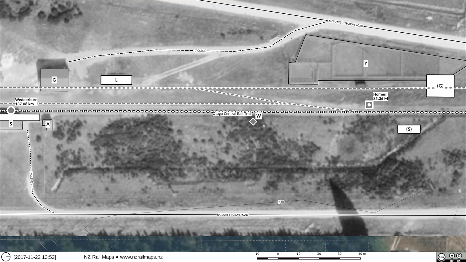
That pretty much completes all the maps for Alexandra to Ranfurly, except for the Chatto Creek one that I will redo with an aerial photo tomorrow. There are a few stations missing because we can't get good quality aerials for them. Obviously Galloway is one of the ones I did from a poor quality photo that I won't bother to trace over, and Auripo is another. I have yet to be able to locate anything good enough of Ranfurly itself, and Ida Valley coverage currently isn't old enough, as this station closed in the 1970s. Retrolens is constantly scanning new material and in time a lot more will come on stream, but not for the immediate needs of this article series. OTGW does have a picture of Wedderburn as it turns out, it is one of the colour photos on page 57.

The same challenge exists for Part 3 particularly in relation to the Taieri Gorge section where there has been historically very limited aerial surveys, although again some that may prove useful has not yet been scanned into Retrolens. At the moment there is not good quality imagery of Waipiata, but every other station between there and Middlemarch (except for MM itself) is well covered, as is Sutton. Ranfurly coverage should come up when some of the large surveys of State Highway 85 are scanned; these dating from the 1950s and 60s were probably used in the upgrading of the Pigroot in that era, which was one of the major factors in increased competition to the railway in that time period. I have identified about a dozen surveys that should eventually produce reasonably high quality aerials to fill in most of the gaps, but it is difficult at the moment to see if Auripo will ever get a good map, although Ida Valley should.

Wednesday 22 November 2017

Otago Central Railway [23D]: Wedderburn updated

 This is the Wedderburn site as it looks today.
The south end of Wedderburn in 1965. A rail trail accommodation business has been established on the site of the house that was in the lower left corner. At one time there were as many as five houses at Wedderburn, but three of them seem to have been removed after only a short time as even in a 1939 aerial photo there is no sign of them. No houses are there today. The loading bank seen upper right appears to be a high level bank with a front made out of old rails, probably lined with old sleepers, with earth banked up against it. The rail posts making up the front are still there today but the bank is in pretty poor shape otherwise. High level banks were designed to allow flatdeck trucks to be reversed up onto the top of the bank where they would tip their loads into high sided open wagons. Wedderburn had a coal mine operating nearby which loaded at the station so this may have been the traffic the bank was built to handle. The station building as mentioned in my previous post and shown below on its original site, had an annex added at the south end. These small annexes were common additions to station buildings. However when the buildings were moved, quite often the annex would be separated from the main building structure. This has happened at Wedderburn, Lauder and Waipiata. In the first two cases the station building that was returned in the rail trail era is missing the annex. Wedderburn had double home signals originally and there was a water tank at the south end next to these signals. The chainage charts show a backshunt off the shed road at the south end but this if built must have also been removed after a short life since it does not appear on the 1939 aerial photo.
North end of Wedderburn, 1965. The goods shed at upper left on its original site and next to it the low level loading bank. Low level banks were built to standard truck deck height and with a truck backed up against the bank on the ground, goods could be loaded across the bank to flatdeck or box wagons. They were much more common than the high level type and practically every station had one. The Wedderburn one has a concrete edge and still exists today. At the north end of the station platform (the platform is still in place today) was a toilet block marked as A, the foundations are all that is left. There was another water tank at one time further north from the station building. There were stock yards near the main road.

After the station closed the building and goods shed went to two separate sites and were moved back later on by the rail trail trust. They chose to place the buildings 200 metres north of their original locations, and in the case of the goods shed, it was placed on top of a corner of the former stockyards and the track that serviced these yards. Because of the potential for confusing the relocation with the NZR era I will need to publish two separate maps of this end of the yard, one for NZR and one for present, since the current location of the buildings is best not conflated with the NZR era.

Otago Central Railway [23C]: Wedderburn revision

This is a sample of Wedderburn putting in an aerial photo without revising any of the previous map content. This will only take a little time.

The issue of quality in resizing is down to the interpolation algorithm used. The Gimp default of "Cubic" is actually not too good. So choosing a better algorithm improves the quality, as does saving a Jpeg into a Png before importing it into Gimp. The rotation does seem to lose quality and I don't know yet how this might be addressed.

The aerial shows that Wedderburn is another station that lost the annex at one corner when it was first moved. The relocated building is therefore smaller than the original shown in this aerial. Lauder is another example. In fact with buildings that have been retrieved by the Rail Trail Trust, few are complete.

Otago Central Railway [28C]: Omakau revision


So here are two updated pictures of Omakau. It is just a tidyup with a new aerial image.

I have decided not to change any of the other aerials for Alexandra-Clyde as it will take too long to do. Those maps were very time consuming because they documented multiple changes in yard layouts at the various stations. Instead I will have the aerial photos put into the Major Stations photo album.

So I will get an aerial for Chatto Creek, Oturehua and Wedderburn as part of Part 2. Some of these aerials are coming out quite blurry, unfortunately that seems to be a limitation of Gimp, which should really be preserving the quality of the original image but doesn't appear to have that ability as yet. I will try a less lossy format to see if I can get the historic images to come up sharper. It seems using Windows Bitmap or some other non compressive format can do the job.


Previously about Omakau

Tuesday 21 November 2017

Otago Central Railway [27B]: Lauder [2]

Here are the revised maps of Lauder.


There were two houses at the west end of the yard, both now gone. Some of the other disappeared buildings and features include a trolley shed, station building, platform, goods shed etc. The loading bank, which was the older L shaped style, is one of the few remaining features.
 The station building recently returned to the site, but minus the annex that used to be on the east end of it. It has been put in a different place.
Roads have been altered at the eastern end of the yard. The highway realignment has taken over a small section of rail corridor and the rail trail now follows part of the original highway alignment to make a right angle crossing of the road.
The site today.

Previous post on Lauder here

As photoshopping these aerial photos is so easy now I expect to do all the ones I have, although I haven't totally decided about Alexandra or the old Clyde station yet.

Monday 20 November 2017

Otago Central Railway [51]: Clyde-Cromwell historical aerial based maps

So these have been finally completed. Here are some samples:


And now back to regular service - let's go have a look at Lauder next.

Sunday 19 November 2017

Otago Central Railway [50]: Finishing Otago Central and other maps

As I get to the completion of the maps (or as complete as they can be made) I have to look at how practical that is to achieve and how long it will take etc. So far as the Central goes I have only had access to chainages for 25 miles to 146 miles (about Pukerangi to Cromwell). From other resources available to me, I can still mark in and have been adding milepegs for 0-25 miles for consistency with the rest of the maps and it has been possible to number most of the bridges correctly for that section as well. Whilst there is another chainage book for 0 to 25 miles which I could get a copy of I have decided not to enquire further about this as I am not willing to spend any more money on researching this line, it's cost a lot already and I don't feel there is any real benefit to be achieved at this time.

The initial section of the line which is currently open as the Taieri Gorge Railway also doesn't have much in the way of aerial photography available at this time so it's not possible to fill in all the missing details in the way that has been possible to achieve with the other parts of the line. It may well be the case that over the succeeding two years more high quality aerial photography will become available from the Retrolens website but right now there isn't a lot there. Some details can be filled in from Linz coverage in places.

I am quite certain this part of the project is winding down and will be spitting out the Cromwell maps in the next day or two, then what I need to do to complete my series of articles will be a key priority, and it's assured that the work on the overall project will slow down after that - not stop completely, but it's unlikely to be a daily activity to the extent it has been in the last few years. Also the focus for the other maps will be mainly finishing them as they are now - if there is detail in Linz's photos that is easy to copy it will be copied, but I won't be spending time on historical stuff to the extent I have on the Central.

One of the things that is important to me on all the maps is not to use metricated imperial distances. As previously outlined the measurement namespaces for the two distinct series of measurements, the imperial and metric measurements of most lines, are generally different and not directly convertible, and one of the issues in the rail community has been the use of converted imperial measurements without realising the actual numbers may not be directly equivalent. There are a few places where I am relying on a metric measurement from Over the Garden Wall without being able to tell if it is really a distance that was measured in 1974, or one that has been converted from a previous imperial number, and to the greatest extent possible I have used the imperial measurements wherever I can for places that didn't exist at the time of metrication.

Saturday 18 November 2017

Otago Central Railway [47I]: CG maps fix

Well today I had hoped to get the revised maps of Cromwell Gorge out. Unfortunately a mistake was found with the positioning of one of the aerial photos, which you can see reflected in the wrong position of the riverbed (light blue) as seen in the lower left of the image below.

Fixing this has been a non trivial task involving repositioning and realigning three or four different aerial photos (not just the one that covers the railway yard), because as soon as you move one, you have to move the others to keep them aligning at the edges, and then you run into problems ensuring they all keep aligning at the edges. If you have ever seen in Google Earth where features are misaligned at the edges of different image runs, you can understand what the issue is. This is why orthorectified aerial imagery like the stuff Linz supplies for free download is so valuable, because the orthorectification overcomes those alignment problems by correcting the distortions in the aerial photos that cause the alignment issues in the first place. But working from historical photos that haven't been corrected, I just have to make them fit somehow. Fortunately I have had enough of them scanned that there are sufficient overlaps in many cases that a bit of stretching and distorting of an image or a part of it can be done without it being too obvious.

Because of the lost time fixing the aerial imagery, and then the time I will need to realign the railway yard map and the riverbed and the Cromwell township street map, I won't have the CG maps ready before tomorrow. 

This aerial image fixes the positioning errors, but I still have to redraw everything I traced off it to finish the maps. Hence the riverbed and the railway line / yard etc are all in the wrong place.

I have pretty much decided that the maps will be drawn as two sets, as now: the map tiles, which will look somewhat like the image shown at the top, and the overlay tiles, which will look more or less like the image shown above. 

Friday 17 November 2017

Otago Central Railway [49]: Cromwell Yard

One of my favourite ways of illustrating the changes at Cromwell is this "bathtub" analogy in which a clear water representation of the lake as it exists today is overlaid over the top of the yard as it historically existed. As with all of the georeferenced historical imagery we are using for these maps, it is a representation not reality. When the line closed the buildings were of course removed, the site was bulldozed, and you can't actually see the bottom of the lake because the water isn't clear as is shown here. Still, it is a good illustration.


NZRM: The week in retrospect

Well it has been a different week looking back, because although a great deal of work has been undertaken over many many hours, virtually no new railway knowledge has been added. The time spent on redoing the Cromwell Gorge maps has been mainly for historical information, and not information particularly about the railway as almost everything that was known about that part of the line had already been discovered with the previous map drawing process.

So whilst I am very pleased to have spent the time on redoing the Gorge and will over the next couple of days be working to replace the existing maps with new ones, I won't be sad to leave that part of the project behind and get back into writing my second article about other parts of the line. I still have to revise some yards between Omakau and Ranfurly for Part 2 but the CG stuff has taken priority because with the imminent publication of Part 1 the maps for that section have had to be put online so that people can look them up when they read the article.

There have been other things happening in my life this week as well that mean I am fairly firm about the expected wind-down of this project around the end of this year, or as soon as the Otago Central stuff is completed. There is a Part 3 article due out as well at which time I expect to have completed the Otago Central maps altogether and be looking at other things. Probably finishing the Main North Line coincident with its reopening will be the next priority. But the overall level of activity will be much less than all the effort I have put into the OCR especially this year, because that is how it has always been planned to happen, or certainly since earlier this year. Originally the expectation was that all the maps would be finished by the end of this year and I worked very hard on it, but later on I revised this and gave myself two more years to finish off after this year but with the expectation that the work output after this year would be significantly reduced in pace. That has become even more certain of late and it's very unlikely there will be any change in that expectation.

The revision of CG content will be finished today probably and the maps updated over the weekend. I have still to conclude what formats to output the new maps in, for example how much use to make of the experimental parallel maps I produced some samples of earlier this week.

Otago Central Railway [48A]: Cromwell Gorge remnants - Waenga

In a number of locations in the Cromwell Gorge some remnants of farm or orchard properties can still be found today. This contrasts with my earlier portrayal of the Gorge as a sterile barren place. The use of the historical imagery in georeferenced form is driving these discoveries.


The first two photos are the maps from the historical and current aerial views and the last image is what is on the ground. In other words the extensive trees seen at a particular location at Waenga.

Wednesday 15 November 2017

New map formats: Samples

Here are samples of the side by side maps. These will be produced alongside full size versions of both types of map, this one is just for an easy comparison.


The reason for having the disclaimer on these photos is that the aerial photography will not perfectly align so that in places, misalignment is readily apparent and results in displacement of features from their real positions.

New map formats

Due to the need to do some new things some additional map formats have been added.

For the map books, the previous map size was half of an A4 page, and the maps were always orientated so that straight up was north. The standard map size is now 1/3rd of an A4 page, and the map is orientated so that the rail line goes from left to right. This is a much more compact format that has resulted in significantly fewer pages in map books. If you have seen the size of the Northland maps that was the first map book we produced with about 130 pages, compared to the size of the Nelson maps that came out recently with the new format, the page count has been knocked back massively. In order to address where needed a bigger size of map within that format there is also the option of having maps that occupy 2/3rds of a page or a full page where needed.

For the online map tiles, whereas the format up to now has been A4 landscape, we have sought to address the difference in screen aspect ratio by changing the size to 16:9 which is more relevant to today's widescreen devices. For putting two maps side by side, an 8:9 format has also been developed. These two online formats will start making an appearance in future uploads and blog postings. In particular the new Cromwell Gorge maps will use a side by side online format for comparing the historical and present day aerial photography.

Otago Central Railway [47H]: New maps Clyde-Cromwell

So after a lot of tidying up and adjustment I have started revising the maps from Clyde to Cromwell.
The reason for all this photoshopping is I have felt that having the original aerial photography as a background is better than trying to draw a lot of features on a map that aren't a complete representation of what is on the ground. The original aerial photography shows a lot of detail that doesn't exist today so bringing it in on the maps is a really good move.

The above image shows where the dam sits just above Clyde and where the railway, old highway and Fruitgrowers Road were in relation to it.

 On the west bank of the Clutha River near the Clyde town bridge is where Fruitgrowers Road starts. The old route of Fruitgrowers Road went off the south side of Earnscleugh Road just before the bridge and followed the riverbank. It was a fairly serious dirt road that ran for miles up the west side of the valley, not quite all the way to Cromwell. In this picture you can see where it starts to the right where cars are parked. With the dam construction most of the road above the dam is underwater so a new Fruitgrowers Road was built, this is the one that curves round to the left in the picture above. The big difference is that just past the dam it turns into a rough track, this is because there are no orchards or farms up there any more as all the flat land has been inundated.
This is down the old Fruitgrowers Road, which these days loops around to go back under the Clyde bridge. The road used to continue where the gate is now. 

Monday 13 November 2017

Otago Central Railway [47G]: Progress

So what you can see here is part of the Gimp project for all the aerial images for the Cromwell gorge.

So a few days hard work has seen all the aerials get put together and the bulk of the work needed to merge the 1962 aerials with the georeferenced Linz aerial photography has now been completed. When I first started working on this I was doing one tile at a time, but because the historic aerials frequently overlap different tiles, it is just that much easier to pull everything together into one Gimp project file and then cut out the individual tiles at the end.

There is a bit of tidying up needed of the images then they get cut back into their respective tiles to be loaded back into Qgis where the maps can then be revised, updated and published. I am keeping it simple and not doing too much tweaking in Gimp, only what is really needed. Lightening up all those dark bands of aerials is one of the things I am doing.

So I expect the revised maps will be ready by the end of this week.

Otago Central Railway [47F]: Samples


I think a reasonable effort has been made to show where the lake is today as distinct from some of the other areas where old black and white aerial footage has been rendered.

Sunday 12 November 2017

Otago Central Railway [47E]: CG aerial samples


So a lot of hard work, a lot of fun, and this is just a beginning, there is going to be a lot more tweaking to get this all done this week. And I am prioritising everything to get these maps finished this week.

Otago Central Railway [47D]: CG aerials with masking

So this layer mask thing turns out to be really simple. Here's what about an hour's work this morning has achieved with one out of seven large images (which had already been overlapped yesterday) and one small area at the middle left. In other words I have taken the images I had yesterday and just added masks to the background layer (the Linz aerial photography) so as to make the foreground layers (the historic aerial imagery) show through the lake bed.


So I have decided to use regular boundaries on the mask because this is just a representation, however I am considering all the angles. You can see bits of lake poking through here and there, that is because I actually don't have a historic image to cover that bit, because I didn't get the entire range of them scanned originally. I will just wait until Retrolens scans that series and then fill them in later.

There are a couple of other things to work on:
  • finding a way to lighten up the darker images to make them look similar to the lighter ones so we don't have that banding with different coloured images. They obviously scanned differently when they put them through the scanner.
  • Using the cage deform tool in Gimp to deform some of the aerials to make them line up better. This will make them blend better at the edges because that is an ongoing issue.