Wednesday 30 January 2019

NZ Rail Maps Project Direction/ Development Proposals [2019C]

After considering the matters raised in previous posts I have decided to go ahead with creating all 12 volumes simultaneously this year.

One of the most significant reasons for this is that I do not have up to date content for a significant number of volumes of the maps and it's been a consideration on migrating to a new platform whether to bring across the old content completed in some cases up to seven years ago or work towards updating all the content as rapidly as possible and publish that. In many cases with the old content there are lots of fairly obvious mistakes that need to be fixed up and it only takes a little effort to add in a few extra details here and there.

It means in a practical sense there will be lots of time spent downloading aerial photography of the entire country and integrating it into the volume which has been a major time consuming exercise but these days I do have that down to a fine art.

Volume 12 will be completed to a Comprehensive level for at least the Otago Central line, as has been a key priority for the last couple of years. All other volumes will be completed to a Basic or Intermediate level but there may be parts that are comprehensive within them, as I may draw maps for particular stations depending on the interest level from the wider NZ rail community.

It will be interesting to work on the maps in Northland that haven't been updated in six years, or the ones for Auckland, the East Coast Main Trunk, or anywhere, and be able to update those maps quickly when there are known changes that have taken place, an example is the recent realignment of a hundred metres of track in Otaki due to a highway project.

Monday 28 January 2019

NZ Rail Maps Project Direction/ Development Proposals [2019B]

Following on from my post earlier today, I will be working on the direction proposals over the next few days and probably there will be a conclusion by Friday.

The twelve volumes are as follows and the work on each volume to date can be summarised as follows:
  1. Volume 1 - North Auckland Line. This route traditionally ran from Newmarket (Auckland) to Opua, a total distance of 181 miles. Its branches have run to Otiria, Port Whangarei, Dargaville, Donnellys Crossing and Riverhead, with the Opua to Kawakawa section latterly a branch that is now a heritage railway, and the expected development of a branch to Marsden Point a present day reality. Volume 1 was our very first fully completed GIS based volume as a set of diagrams with tabulated data in PDF format, back in 2013.
  2. Volume 2 - North Island Main Trunk. Traditionally it ran from Auckland to Marton, just over 309 miles in length. The modern day route for Volume 2 is assumed to run from Wellington to Auckland and be some 680 kilometres long. Branches of the NIMT or private industrial lines have been opened over time to Newmarket, Onehunga, Manukau, Mission Bush, Waiuku (incorporating a present day heritage railway), Glen Afton (incorporating a present day heritage railway), Wilton Colleries, Raetihi, Foxton and Johnsonville (formerly part of the NIMT itself). Parts of Volume 2 have been sporadically completed but no full volume has been developed.
  3. Volume 3 - East Coast Main Trunk. ECMT is a modern definition that was first imposed in the late 1920s when it was applied to a collection of lines that ran from Frankton to Taneatua. The first 44 miles at this time was originally designated in the Thames Branch and the original start of the ECMT itself was at Paeroa from which it ran to Taneatua at 110 miles. Due to realignments, reassignations, deviations and closures, the ECMT currently is designated from Frankton to Kawerau, a distance of 182 km, and branches, industrial lines or bypassed sections are found in the form of the Paeroa-Pokeno Corridor, Cambridge Branch, Thames Branch, Kinleith Branch, Rotorua Branch, Mt Maunganui Branch, Taneatua Branch, Murupara Branch, Matahina Tramway, and Paeroa-Apata Bypassed Section resulting from the Kaimai Deviation which incorporates a present day heritage railway. Publication has been of sporadic sections but a PDF volume was started a few years ago and has had only the tabulated data created so far.
  4. Volume 4 - Marton New Plymouth Line. This is the modern designation for what was originally the Marton to New Plymouth section of the Wellington New Plymouth Line, which was 253 miles long. In its present form it has a length of 212 km and it incorporates branches, industrial lines and bypassed sections at Stratford-Okahukura (including a current tourist railway), Whanganui (including a current heritage railway), Waitara (including a current heritage railway), Egmont, Opunake and Fordell-Okoioa. Volume 4 is in current development to a Basic level.
  5. Volume 5 - Palmerston North Gisborne Line. This route is 243 miles or 390 km in length. It  incorporates branches, industrial lines and bypassed sections at Moutohora, Ngatapa, Frasertown and Napier Port. There are two present heritage railways based in Gisborne and other heritage efforts in the Hawkes Bay section. A PDF volume of map diagrams was completed in 2014 as "Volume 8" and covered only the Napier-Gisborne section.
  6. Volume 6 - Wairarapa Line. The route has always run from Wellington to Woodville. Originally 115 miles long it is now listed at 171 km approx. It  incorporates branches, industrial lines and bypassed sections at the Melling Branch, Melling-Haywards, Silverstream Bridge - Silverstream, Hutt Park, Gracefield, Rimutaka Incline and Greytown. There are or have been a number of heritage railways around Wellington, Featherston and Pahiatua. Volume 6 has only been developed sporadically to date.
  7. Volume 7 - Nelson Section. The maximum extent of public operation reached Kawatiri, some 103 km from Nelson. This is the only volume based around a completely closed section. Apart from documenting this section and heritage efforts at Nelson and Tapawera, this Volume also takes in partially developed corridors from Gowanbridge to Murchison and Inangahua, and from Nelson to Blenheim, as well as an industrial tramway at Dun Mountain. A PDF publication of a set of diagrams was completed in 2013. A second edition was completed as "Volume 8" (a different use of this designation from the Volume 5 publication referred to above) in 2017. A full set of maps with aerial photography background have been published online.
  8. Volume 8 - Stillwater Ngakawau Line. This modern designation (164 km) covers what was historically the Stillwater Westport Line (84 miles) and the first 19 miles of the Seddonville Branch. In addition to those areas there have been branches, industrial lines or bypassed sections at Westport Port, Conns Creek, Denniston, Granity, Ngakawau, Charming Creek, Cape Foulwind, Mokihinui, Burkes Creek, Blackball and Roa, and heritage efforts in the area of Westport and Reefton. This has been a sporadic development with no real effort at putting together a complete set of maps or a PDF.
  9. Volume 9 - Midland Line. This has always been the designation for the line from Rolleston to Greymouth (130 miles, now 211 km). There have been branches, major industrial lines or bypassed sections at Whitecliffs, Avoca, Ruru, Rewanui, Rapahoe, Greymouth, Hokitika and Ross. Heritage efforts include Springfield and Shantytown. There have been many industrial tramways along the West Coast section of this line not mentioned above and there is only limited coverage of these in the maps due to restricted availability of historical documentation. Volume 9 has not been pulled together into a complete publication to any real extent to date.
  10. Volume 10 - Main North Line. What we now know as the Main North Line was originally several different parts, such as the Great Northern Railway from Christchurch to Waiau, the Cheviot Branch from Waipara to Parnassus, and the Picton Section from Picton to Wharanui. The current use of this designation applies to the 216 miles or 348 km from Addington to Picton. Branches, major industrial lines or bypassed sections have existed at Waiau, Oxford and Eyreton, with heritage efforts at Blenheim and Waipara. A complete volume of diagrams (for the main line only) was produced in 2012 and appears to have been the first coordinated effort to produce this form of publication in this project, followed by volumes for each branch individually.
  11. Volume 11 - Main South Line. Originally part of the South Island Main Trunk it ran from Lyttelton to Bluff over 392 miles and is currently Lyttelton to Invercargill at 601 km. It has the most branches, major industrial lines or bypassed sections in any of the maps volumes, including those at Ferrymead, Southbridge, Little River, Methven, Springburn, Mount Somers, Fairlie, Waimate, Kurow, Ngapara, Tokarahi, Moeraki, Shag Point, Dunback, Makareao, Port Chalmers, Walton Park, Fernhill, Outram, Roxburgh, Kaitangata, Catlins, Tapanui, Waimea Plains, Waikaia, Waikaka, Glenham, Seaward Bush and Bluff. There are a number of heritage efforts around Christchurch, Ashburton, Timaru, Oamaru, Dunedin and parts of Southland. Parts of the main line and some branches were put into PDFs in 2012 and 2013.
  12. Volume 12 - Otago Central Branch and Kingston Branch. These major branches of the MSL which also have other branches were put into a separate volume to reduce the size of Volume 11. The Otago Central Branch from Wingatui to Cromwell was 147 miles, and the Kingston Branch from Invercargill to Kingston was 87 miles. Branches, major industrial lines or bypassed sections have included Wairio, Ohai, Mossbank, Tuatapere, Orawia, Browns and Mossburn. A considerable heritage effort has been incorporated throughout the entire Otago Central corridor, and there have also been other heritage efforts at Mandeville, Kingston, Fairfax, Te Anau, Lumsden and Wairio. An early PDF volume for the Otago Central Railway was produced as a set of diagrams in 2013. The second revision of this as "Volume 17" was started in 2015. A major effort to produce a Comprehensive set of maps for this volume has been underway in the past several years and is ongoing.
The maps incorporate a number of formats and these are being kept as they have been developed to this point.
  • Maps are the format that incorporates aerial photography background (colour and monochrome) and are only published online. The online format is essentially a photo album with a series of tiles that can be serially scrolled through. These albums can be downloaded to a device for offline use.
  • Diagrams are the format that includes only greyscale information and are designed for low bandwidth online use like Maps, low resource offline use via downloading the photo albums to a device, and PDF publication. The latter is the format that is optimised for a physical format such as printing on a home printer, photocopying and a bound volume that can be produced by a print shop. 
In both formats, full track layouts are included, and the main difference is in the background to these maps, the Maps format including aerial photography, and the Diagrams format including greyscale terrain rendering. Diagrams are subtyped into an online format and a PDF format.  The PDF format for recent editions has focused on efficient space optimisation to reduce the number of physical pages and therefore production cost.

In revising this table of information about how the project has been published to date I have discovered there was quite a lot of diagram publication prior to this time, particularly in the South Island. The early PDFs used a relatively inefficient layout and the largest one produced was around 150 pages. With the work that has been done to optimise the use of space into the PDF editions, we expect each volume should compromise a maxmum of 50 pages but it will be interesting to see when Volume 11 is first produced in a complete PDF how close to this goal we can come.

As the Wordpress blog for the project probably has sufficient server capacity (in its free Wordpress.com form) I expect all 12 PDFs should be able to be hosted there directly and so there would not be a need to have them separately hosted on Scribd although copies might be placed there for the sake of wider availability. Google Photos would continue to be used for all online formats.

NZ Rail Maps Project Direction/ Development Proposals [2019A]

The organisational scheme of work on NZ Rail Maps is currently being reconsidered.

At the moment I am considering whether to focus on one volume at a time for publication as I have done so in the project at various times, or work on multiple volumes simultaneously as I have lately. I spent much of the past couple of years primarily focused on the Otago Central Railway which is a part of Volume 12 in the 12-volume organisational scheme of the Maps. But throughout that time I would take breaks to work on content in other volumes, and I would also respond to requests for material covering anywhere in the country.


At the same time I have had to migrate content off Flickr and Google Plus due to changes on those platforms and haven't yet reinstated access to all previously published content from the new Wordpress blog that I have set up to coordinate all of the content in place of the Trainweb site that responds to requests for www.nzrailmaps.nz. Partly this is because of a conflict between whether old content should be reinstated as an interim measure, or whether it would be more productive to revise and republish old content to bring it up to date.

The possible approach that is being considered is to work on all volumes more or less simultaneously with a goal of publishing all 12 volumes online at a basic level by the end of 2019. This would ensure that at least there is a basic level of maps fully available within a reasonable timeframe. At the moment the project is hampered by a conflict between making all content available at a basic level, and developing selected content at a comprehensive level. Comprehensive content is much more time and resource intensive as the development of the Volume 12 maps and other selected areas has shown. Basic content can however be put together in a relatively short time as is shown by the development from scratch of the Volume 4 content over the past month and its progression towards release.

So therefore a new development strategy could look like developing all 12 volumes in 2019 to a basic level and publishing all of their content online and with a PDF edition as well. It means the comprehensive development would be slowed. I am working on various stations around the country at present at a comprehensive level as a sideline to the basic level development but this is going to be fairly random although lately I have spent time mostly in North Canterbury with the Main North Line and Waiau Branch featuring. 

Most of the work for a volume consists of setting up the volume structure as a specific Qgis project (these are being generated from what was formerly six projects covering regions, into twelve projects covering the individual volumes) and downloading the free Linz coverage for the area covered by each volume. The latter is particularly time consuming due to having to keep within a download limit of 3.5 GB, the multiple different layers of data covering a particular volume, and the need to select just a part of each download to cover only the rail corridors in order to conserve computer resources. Only once all of that setup work has been completed can the task of map revision begin.

I now have after about a month's work a Volume 4 structure almost complete along with the map revision and this will be completed in just about a couple of weeks. The basic level of content has been largely informed by this and other map volume development over the past few years and especially by the lack of historical content for the Taranaki region which currently has no official Retrolens coverage. There will be three levels of content development under this scheme for the maps:

Basic Level includes the following:
  • Linz contemporary aerial photography at the highest possible and most recent timeframe available for the entire area of each volume.
  • Inclusion of all railway infrastructure that is visible within the Linz aerial photography
  • Marking/labelling of historical or other non-included content (usually this will be a station symbol or some other symbol that marks the location of a historical railway site or installation)
  • Publication of a set of diagrams (maps without aerial photo background) as well as the maps that are with aerial photo background, online.
Intermediate Level includes the following:
  • All of the Basic level content
  • Diagrams and maps of content that has previously been developed for an area and which is available without a matching aerial photography background. For example we did develop content previously that made use of other aerial photography based sources but did not actually publish that content with an aerial photo background, partly because it was developed prior to the use of georeferenced aerial photography in the GIS.
  • PDF for each volume produced. This includes a brief history and tabulated data for all of the lines included in each volume.

Comprehensive Level includes the following:
  • All of the Basic level content
  • Intermediate level content where there is no orthogonal aerial photography available for an area at the present time.
  • Georeferenced historical aerial imagery mosaics which are published as part of the maps along with the diagrams generated from them. 
  • PDF for each volume produced. This includes a brief history and tabulated data for all of the lines included in each volume.
In recent timeframes there has been widespread Comprehensive level development of Volume 12 and the same at a lesser scale in other volumes all around the country. It is now proposed to focus on Basic level development of all 12 volumes to be able to complete them at this level in 2019 and at the same time continue sporadic Comprehensive level development randomly throughout all 12 volumes without a predetermined plan or timeframe for completion.

Whilst it is important to continue with the Comprehensive level development especially in Volume 12 I would certainly like to be able to get every volume produced at Basic level as quickly as possible so that at least we have content from every volume that people can make use of which isn't the case at present. This means the completion schedule of Volume 12 would be pushed back.

All map content remains free of charge. Whilst the above structure does resemble the way that some publishers structure content with free and paid levels, we have no plans to produce anything like this.

Saturday 26 January 2019

Marton New Plymouth Line [0D]: Project Progress Report [4]

Quick update on the MNPL. Have been doing a few different things this week but today I started working back from New Plymouth and Waitara back to Stratford putting in the detail over 50 km of route so that part is completed which is pretty good as it would only take a few more days to complete all of the volume. Just checking overall progress and basically the following is needed to complete the entire volume for the MNPL (Volume 4):
  • 13 km of the main line from approx Te Roti to Stratford to be detailed
  • 10 km of the Egmont Branch to be detailed and aerial photo coverage extended
  • Opunake Branch to be aligned and detailed
  • Manaia branch to be aligned and detailed
  • SOL to be aligned and detailed. Currently aligned up to the first 10 km out of the total 143 km.
  • Various bits and pieces such as gaps in aerial photography and some of the detail around Whanganui to be completed.
Overall the progress is fairly impressive, the major task at the moment being to do the SOL. I expect it will take about a week to complete the SOL outright and maybe another week to tidy up the other bits and pieces. This means it should be near completion by the middle of February.

Wednesday 23 January 2019

Waiau Branch [9A]: Rotherham Station

Rotherham was the ninth station on the Waiau Branch. Using the information from pages 205 to 207 of Les Dew's book, "The Great Northern", we can see that it was a very ordinary station that was operated over a 63 year period - from 1915 to 1978 when the line was closed. When the line was part of the MNL, it was located at 76 miles 2 chains from Christchurch, which was 35 miles 47 chains from Waipara when the line became a branch.

Rotherham these days is a very small locality with just a couple of major streets, one of which is the main road. This was formerly State Highway 70 until 2004 (Google Maps still erroneously shows it as this designation), and is now the Inland Kaikoura road from Culverden to Kaikoura. Rotherham has been known in the last few years as the epicentre of the so-called "Kaikoura" Earthquake of 2016.

This diagram is from Les Dew's book.

This shows a very ordinary type of rural station with limited facilities. The station building however was one of the largest on the line, it has been suggested that Rotherham was going to be the terminus of the line. When the terminus moved to Waiau four years later, it is odd that the station was not moved at the same time. Perhaps it was felt that the Rotherham settlement was large enough to warrant the additional capacity of this station building. It has been a surprise to see two houses on Dew's diagram and the older aerial photos because the station was unstaffed when the railhead moved to Waiau. Again it's a question of why the houses were not moved as well. Probably they ended up being occupied by surfacemen.

The corresponding diagram from NZ Rail Maps (traced from the aerial photos) is as below:
I haven't shown the exact same area, only the detailed area so Hendersons Road is not shown on my diagram (I will show it on the zoomed in versions of the maps posted below).

Rotherham Overview

This map shows the township along with the position of the railway yards.


As we can see, the railway station was about 700 metres from the main street of the town.


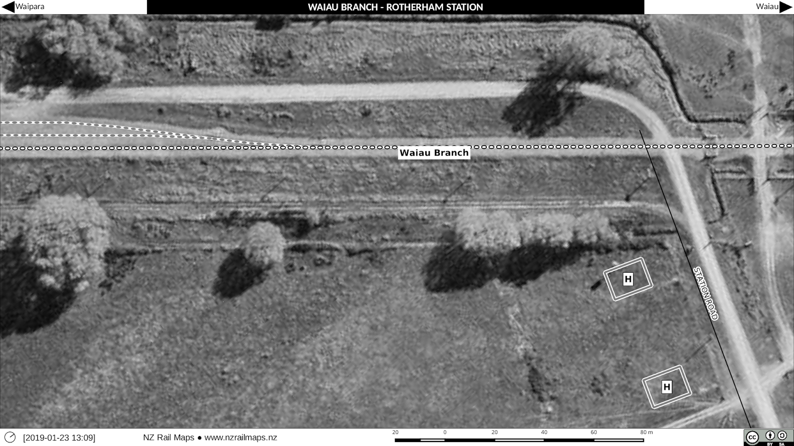
We now turn to the detailed aerial photo maps of the station yard as follows. Aerial photos used are from 1966, 1975 and 2013. Since the 1975 aerial photo is by far the best quality of the historical images, what did we gain from a 1966 aerial? This one did in fact show the stockyards and the houses, which had all disappeared by 1975. The goods shed was removed in 1975 but is still visible on the aerial photo taken that year.

South end of the station yard

This series of maps shows approximately a third of the distance between Station Road and Hendersons Road, at the Hendersons Road end. There is not a lot to see in these maps but we can note that the buildings present on private property along the eastern boundary of the railway do not exist today.


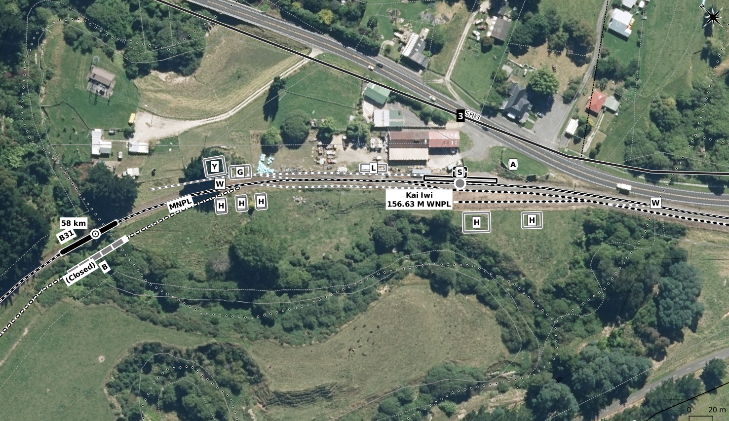
 Middle of the station yard

The middle third of the yard area has most of the interesting parts in it.Again we have used 1966, 1975 and 2013 aerials in that order.


The only clearly discernible feature remaining on the ground is one of the loading banks. However, as we haven't visited the site in 28 years, it is possible that the other loading bank or the station platform, both of which were present at that time, still exist. 

North end of the station yard

The only real features of interest were the two houses. They evidently were removed sometime between the 1966 and 1975 aerial photos. (Again the aerials used are respectively 1966, 1975 and 2013).


Photos of the yard

This photo is from Dew's book (with original credit).

It shows the station building, the goods shed with a wagon under the veranda, and a stack of sleepers. Note the general condition of the yard and track. The goods shed was itself rectangular, but appears more square in the maps because of the veranda. 

Here's the other photo from the same book, and showing one of the loading banks as well. Stockyards are visible as this was taken in 1968.


The station building taken in June 1986 - eight years after the line closed and well after the track was lifted. This was part of a trip we undertook looking at all extant remains of the branch line at that time. Note the sign board still present.

This June 1986 view of the station platform looking in the direction of Achray makes an interesting comparison with previous photos from when the line was open.

From north of the station, a concrete bridge being reused by a farm access road. The station building can just be seen in the distance. 

It has been suggested this sledge was used to help lift the track. Similar devices have been used around the country for purposes like these for separating rails and sleepers that were held in places by dogspikes. Some track would have been held by screwspikes which would have to be manually unscrewed before towing a device such as this along the track bed. A bulldozer or some other type of road based machine would have been required to pull the sledge. This is how the Otago Central line was lifted, except that they towed theirs with a locomotive. It works by having the loose ends of the rails fed over the back of the device, creating the necessary leverage to rip the rails and sleepers apart.

The original loading bank (with a wooden edge) is seen in this June 1986 view. It was very short and made loading flatdeck wagons difficult.

On the right in this view looking down the yard from the north end, is Rotherham's version of a high level loading bank (as so described in the text). This was around 17 metres long and about 1.1 metres high built in 1968. The more typical structure called a "high level loading bank" around the country is about two metres high and usually is constructed of vertical railway irons driven into the ground and faced with old sleepers. We know that one of this type did exist at Culverden and possibly the ones built at Waikari, Balmoral and Waiau were the standard pattern as well. When the Waiau one was completed in the late 1960s it was cited that the one at Rotherham was unsuitable - because in reality it was a low level bank designed to load flatdeck wagons, and perhaps the original was lower than usual for these types of wagons. The main type of wagon loaded at the usual type of high level bank would be highsiders (L type) which were loaded over the top of their sides rather than through their side doors. This was essential when handling raw materials such as lime or coal, as in these situations the doors were only suitable for unloading.

Looking north along the formation from the Station Road level crossing site. The building on the right is a farm building that can be seen in one of the previous photos.
This view of the station building was taken in August 1990. It had by then been purchased by Weka Pass Railway and was to have been shifted to Waikari to be used for their passenger terminus. However because of deterioration of the building evident in this view these plans were abandoned in favour of the present building there which came from Hundalee. The Rotherham station building was sold for removal in 1993 so it is not present at the site today.

Waiau Branch [0A]: Series numbering for Waiau Branch articles

We have decided to produce a series of aerial photos for the stations on the Waiau Branch. This will be spasmodic with no set timetable and will be fitted around our existing production schedule.

There was no schedule planned originally but because the stations are so small and simple, I have completed a set of maps for Rotherham and expect to do the rest from time to time throughout the coming year whenever I feel like a change of pace.

The series will be as follows:
  1. Waipara - already completed
  2. Waikari
  3. Hawarden
  4. Medbury
  5. Balmoral
  6. Pahau
  7. Culverden
  8. Achray
  9. Rotherham
  10. Waiau
Additional series numbers may be added for coverage of other topics that may be appropriate to add to the series.

The maps for Rotherham were drawn yesterday and I will be posting about them shortly.

Tuesday 22 January 2019

Marton New Plymouth Line [0D]: Project Progress Report [3]

Yesterday's pause to install a new script to speed up the sectioning of aerial photo layers from Linz turned out to be quite a quick operation to complete, and has enabled the aerial photo selection for the rest of the MNPL project to be sped right up. As a result we now have 99% of the aerial photos loaded up ready to be used. So with that there will just be a few small gaps here and there where the downloaded areas and different eras overlap, to be fixed up.

As a result the mapping will be pushed ahead over the coming week and I hope to push it through completed by the end of this month but that is ambitious as I realise there is only one week left of the month so a completion target of a few more weeks might be a more realistic prospect.

Monday 21 January 2019

Marton New Plymouth Line [0C]: Project Progress Report [2]

Following my last post I have nevertheless pushed on with the maps, making life considerably easier for myself by breaking up the workflows. Instead of having a slow, frustrating and often tedious workflow of doing everything in one go, I have the first pass in pegging out the corridor route, and the second pass filling in all the extra details like stations and bridges etc. I often do fill in yard sidings as part of the first pass for a bit of a break from the routine. By making this change, I have in the last two days pushed the completion of the first pass all the way up to New Plymouth/Waitara, and currently I am working on getting the last bit of aerial photography completed, which is 0.1 metre coverage for New Plymouth and Waitara, and all of what is needed for the Stratford Okahukura Line, the Egmont branch and the Opunake branch.

I'll put a little plug in here for the EnzedTech blog as well, as it covers some of the more technical aspects of the map production, specifically the more backroom sort of work that is needed to make the project come together. There is a specific tag in that blog that relates to NZ Rail Maps development, so here is the URL that will display just those specifically tagged posts:


I haven't actually used that tag more than once so far, so there are in fact several posts on that blog  which I need to go back to and tag so that they are included in that listing.

There is going to be a new post shortly about the script that I use to copy aerial imagery. I will be writing this post today and there will be some previous posts that are getting added to that tag today as well.

Going back to the maps themselves - as soon as I have all the aerial photography in place I can work back putting in all the detail from New Plymouth and Waitara to, first of all, Waipuku and then the Egmont Branch, and then back to Stratford and then working my way up the SOL. There are several yards to be drawn in along the way, so I'm not quite sure when I can start drawing the SOL, but I am really keen to get that started.

Saturday 19 January 2019

Marton New Plymouth Line [0B]: Progress Report

The last few days working on the MNPL pushing things along towards New Plymouth have been a pretty hard slog, which is reflective of the nature of all the NZ Rail Maps project if I am going to produce full volumes that use current aerial photography as a background. When I first started doing maps in Google Earth I drew in all the routes and a lot of data using Google Earth's tools, which all had to be done from scratch. When it came to Qgis, I used the Linz data layers by default and brought in some traces of closed branch lines from GE. I don't recall there being any other data from GE that was going to be of any use.

When the maps were first done in Qgis it was relatively straightforward as I just assumed the Linz data layers were correct and that was that. But now with the Linz aerial photography and other data sources available I find that correcting the routes to match the aerial photography and fixing up all the other gaps and mistakes is a hard slog. It's almost as much work as doing it from scratch with GE and it effectively does have to be done from scratch for the first time.

As of this moment of writing this, I have just got past Normanby which is 138 km from Marton. That's about two weeks work to get that far. It's a lot of hard work. I would look at the past few days and say I have pushed through about 30 km a day. Extrapolate that to all NZ and it's clear there is going to be a great deal of work if I want to produce all the maps to this standard.

Because of that I am definitely going to stick to what had been planned previously which is on finishing this volume, going back with Volume 5, Volume 7 and Volume 12. Probably at least for this year all that will happen with other volumes is a reprint as diagrams rather than full maps with aerial backgrounds. I don't see any other full map work happening outside that programme because the above listed have been chosen for being especially interesting and by comparison, pushing through 30 km a day of boring farmland doesn't count for anything.


After non stop work over the past few days to get to where I am now, I am going to take a break for a few days before I finish off the rest of this volume. There is 70 km more to reach New Plymouth and then there is the SOL (143 km on its own) and all of the numerous branches. So it will still take until the end of the month or more to complete all of that. And I won't rule out taking a pause from Volume 4 and doing something else for a while. The SOL will be a lot faster to complete because I already did all the extended data on it some time ago, so it would just be alignment on the aerial photography and therefore could go faster than the MNPL itself has gone so far.

Friday 18 January 2019

Marton New Plymouth Line [3A]: Waitotara - Normanby 1: Bridges 34, 37 and 41 Not used by road traffic

When I first drew maps for the MNPL about five years ago (I had just started to use Qgis but I can't really put a date on it) the NZMS1 maps for the area between Waitotara and Normanby suggested that three bridges around Waitotara and Patea were combined bridges, used by both road and rail traffic. Two in particular, Bridge 37 and Bridge 41, respectively east and west of Patea were explictly labelled as such.

In the course of redrawing these maps I have looked at the information for these bridges again to see if there is any more support for these suggestions. However, I have not been able to find anything that sustains these ideas and have concluded that it is not very likely at this stage that any of these three bridges were designed or used for road traffic as well as their primary rail usage.

If the bridges had been used for both types of traffic there would have been more information available about it because it should have been described in either railway or road documentation for the area, but no such documentation has yet been discovered, whereas other documentation tends to spell against these suggestions.

Here are maps of all three bridges.

Bridge 34 crosses the Waitotara River just west of Waitotara Station at the 78 km peg. A key factor against it being a combined bridge at any time in its life is it being so far from the Waitotara township. It would have been an inconvenient detour from the town to have reached this bridge. On the other hand it is close to the railway station and also close to another road bridge (Limeworks Bridge). At the moment there is nothing to show that the road layout has ever been anything other than what it is today. It appears the abutments of the previous bridge show it was just upstream of the current structure.

Bridge 37 crosses the Whenuakura River just east of Patea. On the one hand, there are overbridges on either side of this one, which would have suited the idea that a main road was sharing the bridge crossing. But on the other hand, in the aerial photography I was able to access, the road that approached on each side was no more than a dirt track, and today is nowhere to be seen. The highway crosses this river a considerable distance upstream. As we do know from previous posts recently, this bridge was severely damaged in flooding in 1922, and was completely replaced in 1930. The photos of the replacement show it was incapable of carrying road traffic. The original probably never did either. Again all I can document here is the location of the previous bridge. The road that did exist was most likely never anything more than a track formed to bring in materials for the new bridge construction in 1930 and any other maintenance needed since then.

Bridge 41 crosses the Patea River just west of Patea. We can state with absolute certainty that the Patea River was bridged for road traffic at Bedford St in the 1870s, the current structure incorporating Bridge 40 being a more modern replacement. There was therefore no compelling reason to need a road being able to cross at this location, which would have been pretty inconvenient for the people living in the township.


Thursday 17 January 2019

Marton New Plymouth Line [2A]: Westmere-Waitotara 1

I have now finished mapping most of the Whanganui area except for East Town and have decided to do a full Volume 4 with aerial photography for the entire route to New Plymouth, branches and the SOL. There will not be any more Retrolens historical stuff done for MNPL as there are no images available for the area, so what is traced onto the map will be what can be seen from the ground in the base imagery only.

At the moment I am getting all the aerial photography needed downloaded from the LINZ site and imported into Qgis which takes a while to sort through. Overlaps at the edges of different batches of aerial imagery are another complication to be resolved.

I have completed mosaics for East Town and the Castlecliff Branch using the aerial photography I was able to obtain. The initial attempt at a mosaic for the Castlecliff route used 0.1 m aerial coverage for Whanganui City which proved to be very demanding to work with as it required up to 64 individual map tiles and massive enlargement of the historical images which resulted in a 12 GB file taxing the computer's memory significantly. Redoing it in 0.3 m aerial coverage only needed up to 16 tiles and produced a 2 GB file. The resolution of the base imagery is unimportant for mosaic tiles because the historical stuff is what is actually visible as we are only using the base to align the historical stuff to for georeferencing and when we need to display the modern imagery the 0.1 metre stuff can be separately loaded in the GIS.

Although no Retrolens coverage is presently available, occasionally there is enough on the current aerials plus a really good Whites Aviation picture for it to be worth while to create a station layout by estimating the size and position of various features in relation to known existing ones and so I drew this diagram of what Kai Iwi used to look like. The WA coverage was from 1949 and 1955 when the station was open, and also confirms the bridge realignment just upmile of the station.


 Here we can see that Kai Iwi was a busy little station in its day, it had the usual things you'd see in a rural station, including five houses for staff. The current station building, which I assume Kiwirail has sold off, is probably concrete, a replacement for the wooden one shown in the earlier pictures which was much larger, and it still sits there on the platform. Pretty much everything else has disappeared. No idea on when the bridge was replaced. The Kai Iwi crossing loop, which appears to be, like Ruatangata, a recent addition (late 2000s) with the extension of CTC on the route, can be seen going out of the east side of the image. The siding which comes off at the west end is not part of the original station layout, so we can assume nothing was left of the original station when the present loop was installed. Prior to the extension of the CTC, only Marton-Whanganui was worked by it, with electric train tablet on other parts of the MNPL converted to track warrant, as well as automatic signalling on the SOL to track warrant. I am unsure as to how far the CTC runs on the MNPL now.

Just to add to all the existing mileage controversies, the Quail Atlas, which created one with their metric distances that vary from the ones in the Working Time Table, has in the first edition used different mileages from the ones I have used on these MNPL maps. Kai Iwi as an example is shown as being at "148.09" miles. Likewise their distance for Marton on the NIMT is shown as being "311.02" miles from Auckland, or "112.00" miles from Wellington. The respective distances from the documentation I am using (NZR W&W track mileage diagrams) puts Marton at 116 miles 28 chains from Wellington and 309 miles 37 chains from Auckland. These distances are the same as the ones in the NZRLS 1947 WTT reprint that is a secondary source for me. Hence once again where have the Quail people got their distances from. Going all the way back to Wellington the early distances are correct and the possible sources of error not at all obvious, but they just gradually creep in.

As far as I am concerned the maps will keep using the mileage sources they currently have, and the key and each PDF volume will have explanatory notes about the mileages (another issue for the maps is I have converted miles and chains into decimal miles, so that the decimal point means the same thing for both imperial and metric distances which are intermingled all throughout the maps). Where some of the Quail stuff comes from is not clear, unless they have a more recent imperial WTT as a source. The problem with changing sources is that the stations that have since closed will not appear in the newer source. This is why I am currently attempting to source a early metric era WTT to have as much metric data from a WTT as possible, and not showing any metric distances other than those which can be obtained from a WTT.

Sunday 13 January 2019

Marton New Plymouth Line [1A]: Whanganui-Castlecliff 1

I am currently looking to bring the maps from Marton to Westmere, the first 50 km of the MNPL, to a conclusion in the next week or so. Probably these will be released as a full set of maps, along with the existing diagrams of the rest of Volume 4. But there may not be a PDF produced at this stage. I am not ruling out an interim PDF, but ideally I still need to find a 1974 era working timetable to be able to include the metric distances for as many stations as possible without reliance on the suspect Quail Atlas distances. Putting in km pegs and bridge numbers without otherwise updating is a quick solution on the existing diagrams and I may allow extra time to achieve just that. I do have all the resources needed to put in WNPL distances and those will be shown along with anything else I can get from official sources.

Here are some recent screen captures:
 Castlecliff station (the sidings have not been adjusted to fit the aerial photo, as is commonly necessary when aerial photos replace diagrams)
 A zoom out to take in the general area of Castlecliff with the various wharf sheds and sidings.
 The area of what used to be Wanganui and in the days of the separate Castlecliff railway, the Town station at the beginning of their line. The Castlecliff line was re-routed several times.
 A look at how things have changed at Aramoho in the last few years. The points used to be right at the end of the bridge, with the frog on the far side, and the road crossing being over the four closer rails. This arrangement which was put in place about thirty years ago has been abandoned around 2014 in favour of having the entire set of points located on the west side of the road. This meaning the curves are sharper but making it easier to maintain the points.
General overview of Aramoho and this one shows the fertiliser factory to the north which had its sidings, some of the track still in place at the present.
Another view of Aramoho Junction that attempts to depict the back leg of the triangle. For the vast majority of its existence this leg did not actually follow the route that I have shown, but until I can get aerial photos of Aramoho in any time frame it is not going to be possible to be totally accurate. However the above will be altered in some way.

Right now I am looking at the Castlecliff line as I do have some aerial photos from 1967 covering most of it although the detail is not too sharp but I do hope with the help from Whites Aviation as well to be able to get that sorted out next week.


National Railway Museum is too small to go it alone

The National Rail Museum is a rail heritage group based at Ferrymead Heritage Park in Christchurch. A date of establishment isn't something I could put my finger on right now, but I am guessing 2003 would be an approximation but it could well be earlier than that. I do recall a number of events taking place in 2003 which appeared to be focused around some sort of official launch.

In fifteen years progress has been slow. Whilst there have been a number of railway vehicles acquired during this time frame, the construction of their key building has been quite gradual. The building is to be a roundhouse, and so far what has been completed is the turntable and the track leading into it.

When I started in rail heritage in the 1980s (which I eventually exited from around the same 2003) there was a lot more going for the various groups in terms of resources, because we lived in a different kind of society where people had more free time and money to give to these groups. The situation is now very different and the various groups find they have to work together a lot more, and some have folded up. Against that reality it's very hard for a new group to be formed and established. The other key factor which has changed a lot is the structure of the national railway network which has been through a process of corporatisation, privatisation and nationalisation. The extent to which the national network has been able to support rail heritage has changed vastly in that time, and is currently a fraction of what it used to be.

The key problems I see for the NRM are as follows:
  • It's on the Ferrymead site yet it is a separate organisation
  • It is a self established group rather than being a national initiative
  • It competes for funds and resources with every other rail heritage group in NZ rather than cooperating with them.
Being on the Ferrymead site will bring competition with every other Ferrymead society and the way it is set up is to be completely independent from even the Ferrymead Railway to which its track connects. As well, they now have a bus in their collection, which brings them into competition with two other groups at Ferrymead which preserve buses.

It can't be denied that when you are in competition with other established groups on the same site that you are all competing for members time, members funds and external funding sources.  The nature of the NRM is that they are completely separate from the Ferrymead Railway, with their own collection that they have acquired independently of that group. Whereas, it may have made more sense for them to be a subcommittee of the Ferrymead Railway and simply borrowing some of their existing vast collection of rolling stock.

Also being at Ferrymead sets them up to be in competition with other rail heritage sites in NZ, most of which are openly or not so openly competing against each other and it's doubtful there will be much support from rail heritage groups in other centres, such is the nature of rail heritage that there is nowhere near as much cooperation as there should or could be. Many of these groups will view the NRM as another group like them rather than being something they should support as a national initiative. The politics of being at Ferrymead, which tends to come across as a grandiose pretentious organisation due to their existence at a nationally significant site, will count majorly against them.

I think that the best future for the NRM would be as a branch of Rail Heritage Trust and established around New Zealand with the rolling stock and exhibits at a number of sites rather than being in one single place, thus being able to attract more widespread support. In my view RHTNZ has achieved much more in creating a national railway heritage collection and initiatives around NZ than NRM has achieved to date, and they have also been able to source additional funding support which NRM would not be able to access.

If on the other hand NRM chooses to stay at Ferrymead then they should merge with the Ferrymead Railway and focus on being a branch of that institution rather than duplicating everything which they are doing at the moment and therefore competing with them for resources.

This post is not part of any regular diversion from the core purposes of NZ Rail Maps and I do not expect to be commenting on this type of non-core topic more than once a year at this stage.

Friday 4 January 2019

Marton New Plymouth Line [0A]: Intro

I have taken a couple of side trips from the main schedule for the maps this year, for just the month of January. These two are Marton-Whanganui and the Nelson line (volumes 4 and 7 respectively). By the end of January I expect to be back at work on Volume 12 and Volume 5 being as explained previously the main priorities for map completion this year.

The part of Volume 4 that will be completed is just from Marton to Whanganui incorporating the Turakina-Okoia deviation that I recently mapped. Whanganui is covered by 0.1 metre aerial photography which is of an excellent resolution for tracing off maps. Some years ago I mapped a lot of the stuff around Whanganui city using various sources other than Retrolens and this will come in handy as officially this area has no Retrolens coverage as yet but I have been able to scrounge a small number of orthogonal photos from various sources including other historic archives that I will use to refer to and mosaic if practical.

I am not mapping any more of the MNPL than this 43 km section. Whanganui is special to me because I lived there in my childhood. But the lack of Retrolens coverage of the area means it's not worth putting much effort into at present. So I don't expect to spend too much time on this set of maps, which is good.


The first photo covers what was the East Town rail yards. Originally East Town was a little further west and this was later called Poutini Street, perhaps when this yard opened. It is now called W(h)anganui. Previously this name was held by the station at Taupo Quay next to the City Bridge (Victoria Ave) which closed many years ago. The station was then moved down to the freight depot site, which has also closed. The triangular junction at this site which used to face towards the original station along Moutoa Quay, was altered to face the other way for the new station, and these days it simply links the Castlecliff branch to the Wanganui branch to serve the sidings down there.


More of the East Town area, including the East Town Shops, the railway workshops for Wanganui. NZR used to have workshops at a number of different sites, apart from the four main centres. The shops at Wanganui closed in the 1980s, and these days nationwide there are just two sites: Hutt in Wellington, and Hillside in Dunedin, which almost closed a few years ago, but held on as a heavy lift site because of the overhead crane housed there, and is now ramping up again for construction of new rolling stock.

From East Town the MNPL carries on across the river to Aramoho and from there continues north to Westmere onwards towards New Plymouth. So Wanganui has had three railway stations. Aramoho was the main line station in the days of passenger services whereby trains or railcars generally between Wellington and New Plymouth would stop there. In fact I remember in the mid 1970s meeting a Fiat railcar there. "Standard" railcars operated the services until 1972, while Fiats continued operating until they were withdrawn in 1977, which was the end of passenger services altogether.

The second station was the one down the end of the Wanganui Branch, which is the line you can see turning southward off the bridge at Aramoho. It ran for 5 km down to the general area of the Wanganui CBD where the Wanganui station originally was, alongside the Town wharf, in the days when the main part of the port was located there. Once the port declined, this station was eventually closed and the main yards were moved further down to the triangle. Wanganui did see passenger services until 1959; the Wellington to New Plymouth services always stopped at Aramoho, with a separate service between Aramoho and Wanganui. There were also services that ran directly from Wanganui to New Plymouth, known as the Taranaki Flyer; these ceased in 1959 and that was the end of passenger services to Wanganui. The station was relocated about 1987 when the junction was turned the other way to link directly through onto the Castlecliff branch.

The line to Castlecliff was built as a private railway and was not nationalised until 1956. It runs for another 5 km roughly to various industries and the more recent location of the port. For example the Imlay Freezing Works in Heads Road, now closed, was a major user of the line, and at one stage they may have had their own jetty to load ships. The wharves at Castlecliff are still used but not served by rail as the end of the line was pulled back a kilometre or two some years ago. In 2006 it was mothballed as there were no sidings remaining in use. It was reopened in 2011 and one of the sites served was an inland port for Port of Taranaki. This operation has since been cut back as Port of Taranaki no longer has container ships calling, so the site is now privately operated for container transfer.

So that's Wanganui in a nutshell and once I get the aerial photos loaded in Qgis and an aerial photo I have of the Castlecliff line mosaiced, as well as more details of East Town drawn in, I will put some more posts up.

Wednesday 2 January 2019

Historic Map Mileages

One of the features of NZ Rail Maps is the decision to only use Working Timetable mileages or kilometrages instead of other sources that may not be accurate. The Quail Atlas is the obvious source of distances that have been shown to be inaccurate. It would seem this is because, instead of digging up the new working timetables at the time of NZR metrication in 1974, the Quail publishers apparently performed their own metrication process, converting their mileages into the kilometre equivalent by direct conversion. The reason this differs from WTTs is that deviations and realignments would add and subtract distance and the existing pegs never get moved so the NZR / KR way of handling this is a long or short mile (or kilometre). So that is the first complication and my case of choosing the working timetable distance makes for some level of complexity because it can be in imperial measurement (miles) instead of km; so I have to put a conversion table into each published map volume.

The second complexity to be addressed is that lines changed around, in the North Island mostly. The changes in the ECMT with sections being assigned and reassigned is well known, but for the areas I am working on at the moment, the NIMT was changed around a lot too. The original NIMT started in Auckland and ran down to Marton, where it joined onto what was then the Wellington to New Plymouth line. Hence the old tunnel numbers on the NIMT started from Auckland and the ones on Wellington-Marton section started from 1 at Wellington (originally on what is now the Johnsonville Line). Bridge numbers and mileposts worked the same. So I have been working on Marton-New Plymouth maps and will shortly publish the full maps for the section from Marton to Aramoho because that is a part of what I am doing, basic full maps for every part of NZ, alongside the detailed maps that are going to be of Nelson, Napier-Gisborne and Otago Central/Kingston Line. I looked at Marton and came up with, from the old WTT, Wellington-Palmerston North being 84 miles 79 chains and Palmerston North-Marton being 28 miles 52 chains, which when you add it up and convert to decimal miles puts Marton at 113.64 miles from Wellington so that will be shown (as WNPL) alongside its metric distance of 180.25 km on the NIMT, also from Wellington. Now a straight conversion of the mileage will show a discrepancy of a mile or two and that could be because of the Tawa Flat Deviation or it could be because of the Milson Deviation and I don't really know at this time.

The difference is going to be seen with stations on the MNPL which will have an imperial distance shown for "WNPL" which is the distance from Wellington so they will run in sequence with Wellington-Marton imperial distances rather than the kilometres from Marton. And for some stations there will not be a metric distance if I can't get one from a WTT. I hope to get hold of a WTT for about 1975 sometime to be able to put in some of the now-closed stations' metric distances, otherwise I am having to use some of the other resources I have. For example the first station up from Marton is Pukepapa, 1 miles 48 chains from Marton, which works out to be 115.24 miles from Wellington and that is the mileage for WNPL that will be shown next to Pukepapa's name. But we can see it is between the 2 and 3 km pegs on the map itself. The first map I looked at didn't show it but the second one did.

Marton, showing the station and the junction and start of the MNPL, or depending on your POV, the middle of the WNPL.

 Pukepapa, first station past Marton.
It's 2008, and these are track machines near the 5 km peg. Probably a ballast regulator and tamper.
There may have been a realignment between the 5 km and 6 km pegs. Probably there was a short steep grade that was worth eliminating.

Tuesday 1 January 2019

Project Updates 1/1/2019

Welcome to the new year. Since the last time I have been busy working on a few sidelines. Maps have been produced in two other areas in particular: a map of the closed Turakina-Okoia route of the MNPL, which was bypassed with a deviation in 1947, and starting to have a look at updates to the Nelson Section maps.

If you recall when the Nelson maps were produced around 18 months ago, they were the very first maps produced that used the contemporary Linz aerial photography as a background to a map, and also the first to draw on Retrolens resources. These changes were quite far reaching as many map styles for railway lines and features on the maps have had to be altered to make them stand out against a background of any possible colour. Most commonly this is done by adding a white outline to the existing grey or black colours that styles use. Tweaking of these styles continues to the present day of course.

It was also the first time I had used Retrolens' historical aerial photos in any measure. These images informed our knowledge in particular of the route taken south of Glenhope to nearly Murchison, as the earliest available are from the early 1940s, at a time when construction works had only been abandoned some 15 years previously, so that much of the formation work was still easy to locate. Hence the maps were able to be very detailed in locating the rail corridor of its time.

What wasn't carried out at the time was the use of aerial mosaics using original aerial photography on top of contemporary as I usually do now. As a result, station layouts such as I would draw them today were not produced. To rectify this omission, I am putting together mosaics for all the stations that I can find, and these will be incorporated into updates of the maps. There will not be overall revision of the maps as a whole, what will be done is to reissue some of the map tiles that have already been published to incorporate these layouts along with any new tiles that may be needed. This includes the Scribd published map volume for what is now Volume 7.

I have also been very pleased to discover much better aerial photography for the background for Volume 7. There is 0.1 metre resolution coverage of Nelson City and 0.3 metre coverage of Tasman District. For the ones I did 18 months ago I had to use some older Tasman District photography which turns out to have a resolution of only 1 metre which is very poor and is the lowest quality I have ever seen on LDS. But I found that for those areas I can now add some 0.3 metre stuff which for some reason wasn't able to be used last year.

I am also downloading the rest of the aerial photography needed for Volume 4. This isn't because I intend to do a lot of work on Volume 4, but because I will take every opportunity to download the aerials for every volume regardless, because I want to have a complete set of basic maps for every line in NZ that I can refer to at short notice. It may well be that every volume will have a set of basic maps produced this year so that the website has a full set of content available, but the updates to most volumes except for 5 and 12 that are going to be top priority this year, will be much more in depth and detailed. Basically with everything else there will be a quick once over just to line everything up with the aerial photos and then a set of maps will be pushed out for public use. This is in line with the previous intentions to issue maps in a new easier to navigate format, except that I intend now to revise everything first.

Apart from the above, I have also been working on Volumes 5 and 12. In Volume 5 in particular I produced a basic set of maps for Wairoa using historical imagery going back to 1942. I now need to get back to producing the  aerial tiles for every station on the route and then get on with revising the maps in general. Volume 12 work continues with production of aerial mosaics (Alexandra will be the next set revised) and drawing in stuff at Clyde.