
The first point of note south of Waikouaiti is Merton, which locally is known for the former Cherry Farm psychiatric hospital facility, closed in the 1990s as part of the first wave of de-institutionalisation of major mental health facilities. For the railway interest, Merton has had three distinct operating locations, of which the two known latter are adjacent.

The original site, according to Scoble, operated only during 1878 and was replaced by the second location just south of the Coast Road crossing, which closed in 1981. The third location which is the dedicated crossing loop at 333.55 km, opened to traffic in 1986.
Continuing south we come to Puketeraki, a station just north of the 338 km peg.

This photo comes from the A P Godber collection of Alexander Turnbull Library and is believed to have been taken around 1925. This station opened in 1878 and was finally closed to all traffic one month after its century in 1978. These days it is hard to place where the station was at ground level.
The abandoned Tunnel No.3 just south of the station is symptomatic of the turbulent history of MSL tunnels, of which there have ever been a maximum of just 10 in a length of 600 km. Tunnel 4 at The Cliffs is not original, but was built some years after the line was opened as part of a deviation. Tunnel 6 near Port Chalmers was daylighted in 1971. Tunnels 8-10 were replaced as part of duplication and regrading work in Dunedin between 1908 and 1948; ironically, all carry only a single main line today. The originals of Tunnels 9 and 10 remain on private land and are still in good condition, and may yet be reopened to cyclists; the old Tunnel 8 was buried under a motorway.

Puketeraki Tunnel taken over 100 years ago (Hocken Library). Note the signal wire going through on the right; as the station was so close to the tunnel, there must have been a distant signal at the south side. In the days of mechanical signals, very long wire runs were the norm and traversing major structures such as bridges and tunnels and also passing under roads was not uncommon. The long cables were susceptible to temperature induced expansion/contraction and their replacement with colour light signals was a highly desirable outcome for signallers and maintainers. This photo appears to have been taken at the north portal.
Here is an extract from a Royal Society of NZ publication referring to the geology of the area and its effect upon the built topology. This puts the date of abandonment of the tunnel being around 1935. (see link at bottom of this post for the full article)
Puketeraki Railway Tunnel.
Some idea of the rate of these slumping movements may be obtained from the records of displacement at the Puketeraki railway tunnel, which through the courtesy of the Otago District Engineer for Railways, the writer was permitted to study (See Fig. 3). The tunnel was cut through a northward-facing bluff of Caversham Sandstone, and enters into what is actually the face of a slump-scarp a short distance above the underlying mudstone. The tunnel is 516 ft. long and rises southwards with a slope of 1 in 66, crossing several major as well as minor surfaces of slump-movement. The displacement along these was soon made obvious by the disruption of the tunnel-lining, and necessitated repeated repair, regarding and realignment. Comparison made in 1932 between the elevations of points taken at 10 ft. intervals along the axis of the tunnel (crown of the tunnel-arch) and those determined at the time of its construction in 1878 (the northern portal being used as the datum-point), showed that there were three main slump-faults between which strips, respectively 50, 150 and 100 ft. wide, subsided with a backward rotation at an average rate of 0° 1′ 7”, 0° 0′ 24”, and 0° 0′ 5·8” respectively per year during the 54-year interval. The greatest differential movement (12 inches) occurred between the middle and inner strip, and this slump-fault is continued upward from the tunnel into the small slump-scarp about 18 inches high on the top of the bluff over the middle of the tunnel. This scarp was thus scarcely in evidence when the construction of the tunnel was commenced.
In order to obtain more nearly the absolute measurements of the displacement of the tunnel-axis a line of sight from a datum-point fixed in the station yard in 1928, and controlled by azimuth-readings to distant trigonometrical stations, was taken as the base-line for measurements of the position of seven points at various intervals along the crown of the tunnel-arch, and repeated measurements were made at intervals between 1928 and 1936. Taking those made before June, 1934, it may be deduced that the annual rate of backward rotation of the middle and inner slumping strips had then increased to 0° 0′ 42″ and 0° 8·2′ respectively, and that the average rate of subsidence at six of the points observed by reference to the seventh point near the north portal (most nearly stable* during the 54-year interval) had increased by 80%, these increases probably resulting from the increased vibration caused by heavier and more frequent trains. The determination of the eastward as well as the downward component of the displacement showed that each slumping strip had a double movement of rotation, the backward rotation about an axis parallel to the face of the scarp, and a seaward slipping also with backward rotation about a line nearly perpendicular thereto; for the resultant direction of lateral slipping is inclined more steeply than the bedding plane of the Burnside Mudstone on which the movement takes place. The average rate of monthly slipping (varying between 0·08 and 0·29 inches) during the several intervals between the successive measurements accords closely with the value of 0·0138 R2.70 inches, where R is the mean of the average monthly rainfall during these intervals at the two official recording stations nearest to Puketeraki (respectively 12 and 16 miles to the N.N.E. and S.S.W.). If R should approximate to the average monthly rainfall at Puketeraki, the above relation may indicate at least qualitatively the dependence of the rate of slipping on the amount of water percolating down the fissures in the Caversham Sandstone to lubricate the sloping surface of the Burnside Mudstone on which it rests.
Between July, 1934, and September, 1936, when the measurements were discontinued, the deviation-cutting and embankment were being built, and the use of the tunnel was abandoned. The displacements of the observed points greatly diminished, and after April, 1935, appeared to cease, in part, no doubt, because of the excellent drainage of the fissures afforded by the new cutting, but possibly also because the extra load imposed by the weight of the 87,000 cubic yards of sandstone, which makes the new embankment on the mudstone in the vicinity of the datum point for observations, may have so increased its tendency to creep seaward as to have reduced below the limits of observational error the movement of the tunnel in reference to that of this datum point.

Auckland Weekly News photo of 1932 (Auckland Libraries, Sir George Grey Special Collections). This location is believed to be immediately south of the tunnel. It is entirely possible that the railway was never reinstated to the original location after this large slip as the map shows quite a sharp curve at the southern approach to the tunnel. It is also possible this event contributed to the decision to commence the tunnel deviation construction some 19 months later.

Recent aerial photo of Puketeraki (LINZ). Compare this with the map below (same scale), the unstable nature of the hillside is relatively apparent, although the above article makes clear that the movement rates in the old tunnel were reduced with the deviation work.


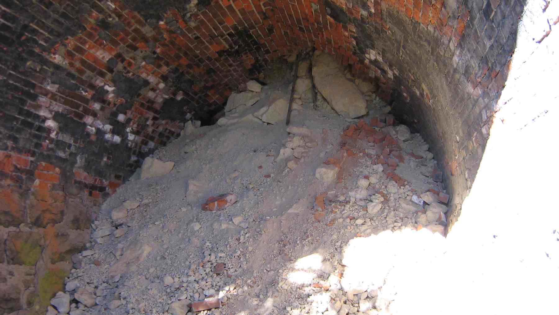
Passing along the deviation embankment on the north end looking across to the northern portal of the tunnel in 2010. Taken from the Seasider train. Clearly apparent is the amount of land movement around this portal which has led to the tunnel collapsing a short distance in.

Closeup of the northern portal from which it can be seen clearly that the tunnel has collapsed a short way in.
Some photos from another blog are below:
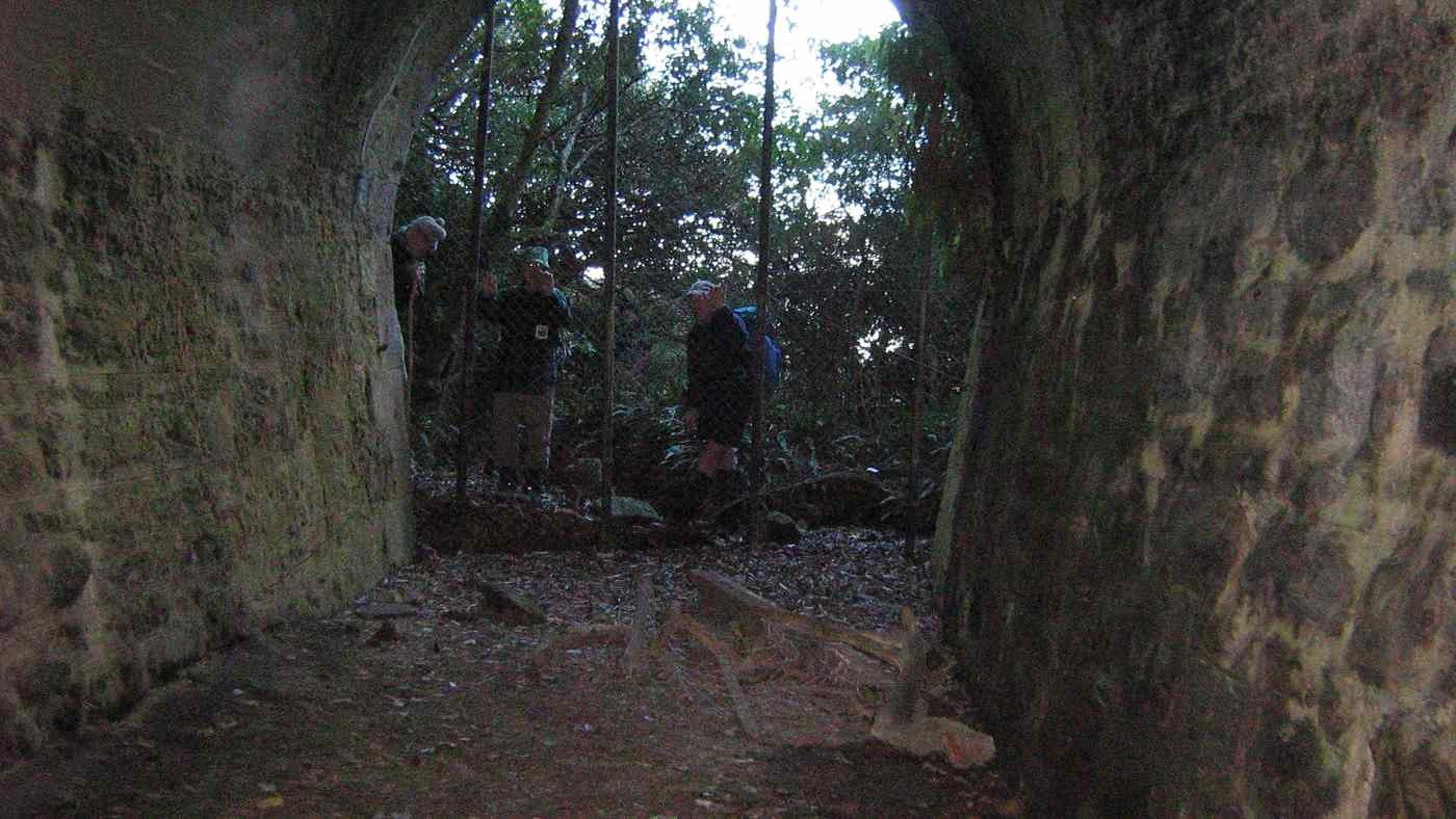
- http://trtc.blogtown.co.nz/files/1996/07/090722.2718.InsideTunnel.jpg - Inside the south portal, the entrance to which is now overgrown
- http://trtc.blogtown.co.nz/files/1996/07/090722.2711.TunnelSlump.jpg - Inside the north portal. A closer view of the collapse.
- http://trtc.blogtown.co.nz/2015/12/02/seacliff-brinns-point-enchanted-forest-round-trip-2/ - The blog article containing these two photos.
- http://rsnz.natlib.govt.nz/volume/rsnz_70/rsnz_70_03_003990.html (RSNZ publication cited above)