
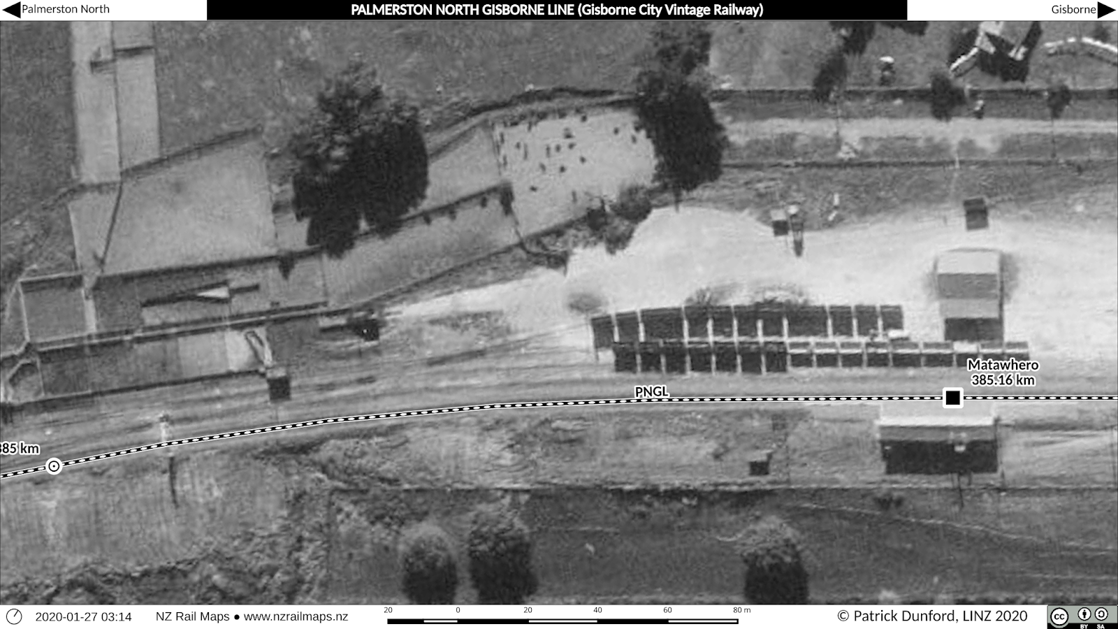
Today we're going to have a look at Matawhero Station. When you head south from Gisborne, Matawhero is the first station south of Gisborne Junction. Matawhero was once quite a busy station, but these days you would hardly know that; obviously its role for GCVR is limited to the crossing loop, but even when the line was opened, in 2012 all it did was connect the Ravensdown premises to the railway network. This change over the years is reflected in the changes in the yard layout and the signalling system. We are going to show just a few aerials and diagrams in this post, but a full set will be available online in the map sets for the PNGL mainline. The final versions of these are still a few days away from being uploaded because it's easier to put them online all at once rather than having to keep taking them all down to add new content (a necessity given the limitations of Google Photos as a tile platform).
We do not have much information on the type of traffic handled at Matawhero, but there is a strong indication that it was the major stock-handling station for the greater Gisborne area. It is very conveniently situated close to State Highway 35 and State Highway 2, and is a good distance from any population centres - an important prerequisite for the often smelly and dirty business of transshipping stock from road to rail. It is possible but somewhat unlikely that stock could have been loaded there for the nearby Gisborne freezing works at the Port, but it seems more realistic that they would go greater distances further south, such as to the various works in the Hawkes Bay. Stock being moved into the region could have come, for example, from the major saleyards at Waipukurau which had its own siding for loading, and obviously from elsewhere. Once NZR got out of stock handling beginning in the early 1960s when stock was exempted from the 30 mile cartage limit, this role diminished greatly, but Matawhero survived in a new role of handling fertiliser traffic through the adjacent Ravensdown depot on Macdonald Road (built in the 1970s) - which continued up until closure of the line in 2012.

Our diagram for a general overview of Matawhero. It doesn't show all of the south end of the yard, but it does show the main facilities. From it, we can see that Matawhero once had quite a large stockyard, a goods shed, a loading bank, station platform and building. None of these facilities are present today; even the loading bank and station platform are gone, although the station building still exists, having been relocated to the East Coast Museum of Technology at Makaraka.
Below are a set of 5 diagrams covering the whole station in much more detail. We also have four aerials for each diagram, covering the eras 1951, 1966, 1986 and 2012. We won't be posting all of these diagrams, just picking one of each era to illustrate particular points.


A closeup view of the main facilities in the yard. At left is the stockyard, and note that there was at one time a scissors crossover in the trackwork in front of it. This would have been particularly relevant for access to that siding we mentioned above, given its proximity to the stockyards. Over to the right we can see the goods shed and station building and platform.

North end of the yard. Apart from some of the facilities we can see in the previous diagram, we can also see the position of the loading bank in this map. Unusually, the loading bank no longer exists today.

In the last of this series of diagrams, we can see how a backshunt off the end of the loop, a small part of which is still used today as an overrun siding, used to cross the main road and continue a short distance on the north-east side.
Here now are some aerials for these diagrams. Check the full set when they come online in a few days.

Westernmost end of Matawhero in 1951, showing the bridge which has been replaced by a culvert. This replacement was part of an environmentally destructive process of converting a tidal river lagoon ecosystem into farmland in this area.

Same area as above in 2012, as well as the culvert we can see the Ravensdown siding coming around the curve as it leaves Matawhero Station to head to the fertiliser store (the next map shows this in more detail)

2012 aerial map of Matawhero showing the location of the Ravensdown fertiliser store. The route of the siding can be viewed as it runs straight down from the works before making a big curve through 90 degrees to enter the Matawhero station yard.

Western-middle section of yard with the stockyards at right. The mystery siding that is connected off one end of a scissors crossover from the stockyards is visible at the upper centre of the map. Given the fact of the installation of that crossover, the siding's its adjacency to the stockyards, its physical distance from other sidings to allow space for some kind of platform or other physical structure that is vaguely visible in the aerials, and the size of the stockyards at Matawhero, we have concluded (without doing any additional research) that this siding was most likely for cleaning stock wagons. Given that Matawhero obviously handled large volumes of stock, the scissors would be necessary to allow wagons to be moved in and out of this siding whilst loading operations were simultaneously occurring at the stockyards - the loading ramp was at the northern end of the yards as shown and this would allow loading clear of the scissors as long as the rest of the rake were further north (towards the goods shed). The additional sidings at the station would also have allowed for a large number of stock wagons to be stored. The scissors also appears to have allowed simultaneous loading and unloading - we don't have any information on Matawhero specifically, but it appears to have separate ramps for these two operations, during at least part of its history, which is not commonly seen, and is another factor that points to a large volume of stock handled there. However as we know from the 1960s onwards, stock traffic was gradually transferred to road and this explains why the stock handling facilities and sidings are no longer visible in the 1986 map.

Middle of the station yard seen in 1966. The stockyards have a small amount of stock in one of the holding pens, and one single wagon is sitting at the loading ramp. A couple of rakes of deckers are visible to the right.
1986 middle yard view. The loss of the stockyards and even the goods shed, and the rake of wagons that probably carry fertiliser, point to the major change in use at Matawhero. The rectangular area to the left of the station building is a bit of a mystery at this stage - one possibility is that it or another similar area further to the south were used for earlier housing at the station, but no documentation has yet been located to support this. By the 1940s certainly the staff accommodation appears to have consisted of three houses next to MacDonalds Road on the northern boundary of the yard - which are still there today.

Easternmost part of Matawhero in 1951. To the upper right appears to be an unknown structure that was gone by 1966 - timber stack is one possibility. Next to it is the loading bank, no longer in existence today.

In the earlier history of Matawhero, a backshunt off the eastern end of the loop crossed the road next to the main line and continued for some distance on the other side. It isn't particularly certain how long that backshunt was, or how long it was there for. There is a possibility it had been lifted by 1966, or alternatively at that time that it was longer than we have drawn it on the maps. A short piece of it has been left in place on the western side of the road as part of the standard safety siding found at each end of a crossing loop to protect the main line from wagon runaways.

The only standalone S&I diagram we have for Matawhero was this one, 1274, dated 1968. Matawhero at that time was a switch-out station with its own signalling panel for controlling the various points and signals within station limits. An interesting feature is located to the south/west at around 236 miles 68 chains - the service siding, more than three miles to the south of Matawhero, and about three miles north of Muriwai. This was most likely at the southern end of the Waipaoa River Bridge (No. 290). There was a siding there during the bridge extension project in the late 1950s and this is probably what the reference is to. We have marked "Service Siding" on the map, but not the distance, as we have no means of confirming that the S&I referred to the same location given the time lapse.
Most of Matawhero was fairly conventional apart from the Departure signals 19 and 5. These signals were controlled by Gisborne station when Matawhero was switched out, but if the station was switched in, Gisborne would give permission to Matawhero to release 19 signals. In other words, if there was no one on duty at Matawhero, Gisborne could clear the signals in either direction. If there was a signalman on duty at Matawhero, Gisborne would still clear trains to depart south, but for trains heading north, Gisborne would give permission to Matawhero to start trains when ready.
Another unconventional feature at Matawhero is the airport runway signalling system a little further north. Signals are provided for both trains and aircraft where the main line crossed the runway. We have not referenced the Working Timetable instructions for operation of this system so are not able to comment on exactly how it operates. As far as we know, however, this section is entirely controlled by the airport tower, which must issue permission for trains to cross the runway. Interestingly there are no safety sidings for the railway tracks.
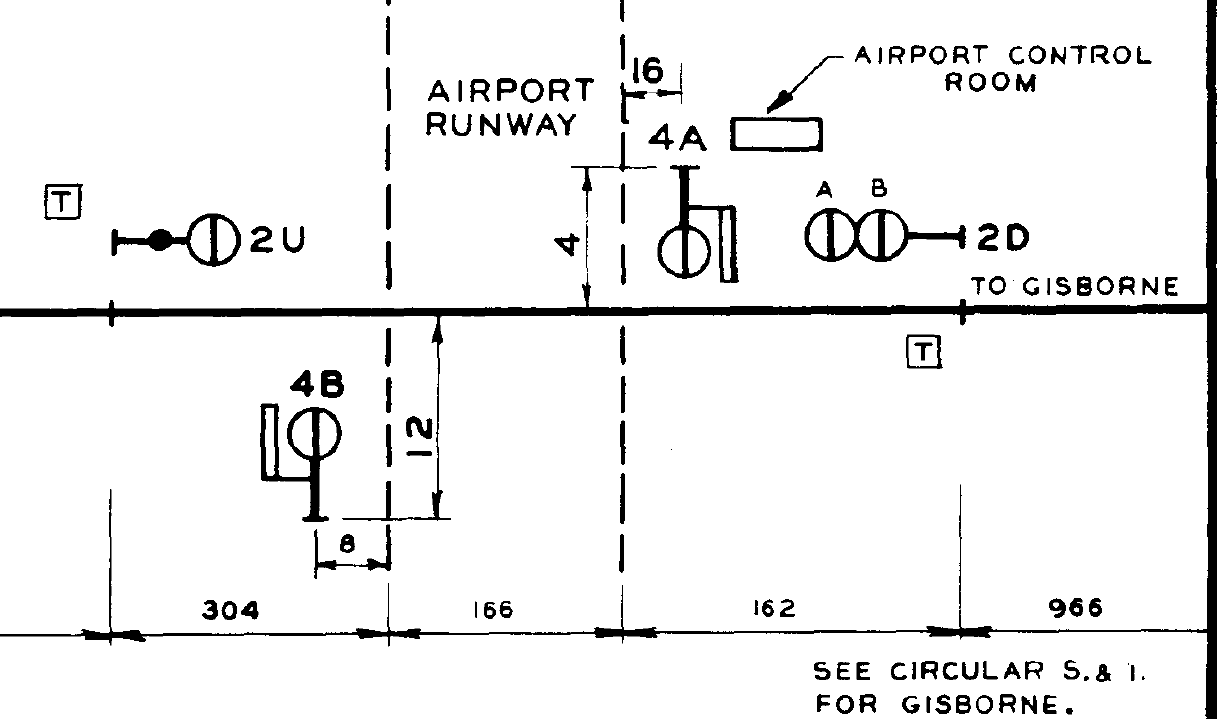
Airport runway signalling system.
Matawhero in more recent years has been included in S&I diagrams for Gisborne Station. This is because the Gisborne station limits were extended to include Matawhero. Since the sidings were added to Awapuni Coolpack and Kiwi Fruit Products north of Matawhero, the station was given control of the switchlocks into these sidings but had to obtain permission from the Gisborne signalman due to the possibility of a train being despatched from Gisborne at the same time.
As we noted in an earlier post of this series on Gisborne Junction, the fully interlocked and signalled switch out station at Matawhero became "Matawhero Sidings" by the time of issue of S&I 2146 of March 1989, at which point there was only a set of paired points (No.2) at the north/east end of the station. At that time probably the traffic was solely fertiliser for Ravensdown as all the other freight handling facilities at the station had been removed by then. However the most recent diagram that was in force when the line closed in 2012 showed that the south/western end main line to loop paired points (No.9) operated by a frame lever had been reinstated by then. By that time also "Waipaoa Siding" 3.5 km to the south/west had been added into a local sawmill.

Waipaoa Siding maps. The south/west end Matawhero points were probably added to enable shunts to/from this siding to be staged at Matawhero as the siding has only a single track with no additional storage or runaround facility for locomotives.
