
So we have shifted some of our focus to the Midland Line whilst continuing to work on the Christchurch area maps. We now have the full set of aerial photography we need to cover all of the Midland Line from Rolleston to Ross, as well as historical tiles of four stations in Canterbury: Darfield, Springfield, Arthurs Pass and Otira, which are all we can get coverage of at the present time. If Retrolens had released more pictures of Otira (the ones they did have, have since been pulled) and the West Coast in general we could expect better quality historical maps of Otira, as well as Stillwater, Greymouth, Hokitika and Ross, so we just have to make do with what we have, and the above four stations are all covered by one form or another of official NZR surveys as well as other material sources. So here is a quick look at each of these four stations in summary as we push ahead with fully detailing the entire route.
Darfield is one of just a couple of "major" stations between Rolleston and Arthurs Pass exclusive, that is, on the Canterbury side. It was formerly notable as the junction until 1962 of the branch line to Whitecliffs. It has always been a small town and its importance derived mainly from the junction purpose and has declined since. There is nearby rail served industry at Racecourse Hill with the Fonterra factory built there a few years ago. Coal mining has been established in the Darfield district for many years and continues to this day, but is mainly lower quality lignite and thermal coals suitable for boilers; it formerly provided much of the traffic on the branch line.

Darfield as seen in 1940. The yard today is much smaller and the buildings are gone.
Springfield is the other "major" station and owes its historical importance chiefly to the siting of a number of major operational functions of the railways, owing to its location at the entrance to the short but highly challenging 50 km Waimakariri Gorge section of the line, the much more modest Cass being at the other end of this section. One of these functions being the steam engine depot serving the massive KB class engines that worked the mountainous section from the mid 1930s until c. 1970. There was a small coal mine at the south side of the town until c.1940 and from the mid 1880s until 1930 a branch line to Oxford traversing the Gorge joined to the Midland Line at Sheffield, a little closer to Rolleston. With the coming of dieselisation the depot and the township with it waned in importance, although operational restrictions kept the engine shed open until the late 1980s. Springfield is now known chiefly for the attempts by a heritage railway group to open a restoration depot there, which has progressed slowly over a number of years with the relaying of the turning triangle and a number of tracks in the vicinity of the old locomotive shed, but with little other obvious lingering presence.

Springfield as seen in 1976. The railway as built in the 1880s and 1890s followed a route through the main part of the township and parallel to the main road. In about the 1930s a deviation was constructed to take the railway along the northern edge as it goes today.
Once having passed through the Gorge and reached Avoca, Craigieburn, Cass, Cora Lynn and Bealey Bridge, all tiny settlements having little other purpose than railway services or entraining / detraining the odd tramper, Arthurs Pass is reached at the eastern end of the Main Divide. This is another former railway township that has taken on a life of its own as a tourist halt on the highway through to the West Coast. For many years the road was of such a bad and notorious character that NZR offered a transport service by which travellers were able to load their cars onto a train at Springfield and bypass the "highway" until reaching Otira, and vice versa. This traffic began to decline from the 1930s with the investment of large sums into highway construction and this trend has continued in recent years with the road over the "Pass" much improved since the old zig zag was bypassed with a viaduct in the 1990s. In the last four or five years there has been a major realignment of a twisty and undulating section of the highway just to the east of the township. Arthurs Pass in railway terms these days is mostly known as an operational stop for the Tranz Alpine train, as the terminus of high powered freight haulage services up the steep grades of the 1 in 33 Otira Tunnel immediately west of the township, and as a popular terminus for many passenger excursions from Christchurch, particularly in the winter months when the area is well covered in snow.

Arthurs Pass seen in 1943, with the original station, the old steam engine depot with first turntable pit, and some of the housing provided for staff. Many former railway houses are now holiday batches in this tourist township.
On the west side of the Main Divide is Otira, which is separated by 14 km of track and 359 metres of altitude. It doesn't take a lot of mathematical knowledge to realise that such a significant descent to Otira would enjoin quite a steep gradient; the entire 14 km section of the Midland Line has an average gradient of 1 in 33, and for this reason, the line was electrified from the time of opening the tunnel in 1923, until the mid 1990s. The section is now worked by larger "banker" diesel locomotives stabled at Otira, and the sight of a heavy freight train setting off from the station with five or six of these 3000 hp engines on the front is most impressive. The tunnel itself is 8 km in length and took some 15 years to construct with manual labour under very pressing conditions that saw the original private contractor forced out of business, the task being taken over by the government and progressed as essential work during World War 1. Due to its length and gradient, special safety procedures apply for all trains and these facts ensure that Kiwirail maintains a staffing presence in the township. Otira was formerly a major operating depot which provided crewing for both steam and electric locomotives due to the change in haulage power, as well as many maintenance staff, but these days the relatively few houses that remain are mostly occupied by tourists.
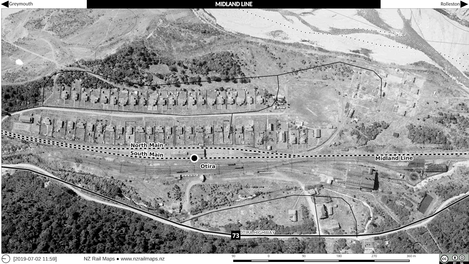
Otira seen in 1943, with the original steam engine depot and turntable to the southern end of the township. A "wye" or turning triangle replaced the turntable in 1958.
The whole geographical reality that besets the Midland Line is that of very sparse population, and thus, sources of freight traffic. Most of what is carried on the line is either coal or milk powder. The coal is mined at a number of sites, all of them on the West Coast, although much of it is of a high and calorific value suitable for sea-borne export via Christchurch. At present the coal is mainly loaded at Ngakawau, Reefton and Ikamatua, all locations served by a branch line to Ngakawau via Westport that joins the Midland Line at Stillwater, at Stillwater itself, and at Greymouth. What population exists on the West Coast is generally concentrated in Westport, Greymouth and Hokitika, the latter location being the other main source of freight, processed from milk production in South Westland. The long term future of the line is heavily dependent on coal production and due to conservation pressures this is likely to gradually wind down over the next decade at which point the future of the entire line west of Springfield is likely to be under a cloud, unless new freight sources are found. Gold was mined at Reefton and railed to Palmerston near Dunedin for processing in recent years, but this has now wound down and whilst other goldmining sources do exist in the region, it remains to be seen if this can be made sufficiently viable to be railed out of the region.
In preparing these maps I have resisted the desire to produce historical tiles of many smaller stations along the route and just stuck with the above four, with some compromises. For example at Darfield I chose only to depict 1940 and 1970. I have put in more generations for Otira and Arthurs Pass where a greater level of change has occurred over a similar timeframe. I also considered the opportunity to research Springfield and discover more about the 1930s deviation but have decided it is not a present priority due to time constraints. As noted in other recent posts the prevailing impetus is simply to complete all 12 volumes as quickly as possible to a Basic status and then focus on expanding the coverage to Intermediate or Comprehensive level if there is sufficient time. As noted above, detailing of the Midland line from Rolleston westward is currently underway and I expect the full volume of maps should be completed within the month, subject to higher priority work in Greater Christchurch due to my other transport interests.