Showing posts with label Volume 4. Show all posts

Friday, 28 February 2020

NZ Rail Maps Project Development Report [2020D]

So here is our latest update on the overall NZ Rail Maps project. As we made clear earlier this year, we are working on completing all 12 volumes in 2020. That is an aspirational goal and for various reasons it's quite possible that goal won't be met. However it is worthwhile making a serious attempt to achieve it, even if we only get 10 of the 12 volumes actually completed by Christmas.

At the moment the schedule has slipped by about 10-14 days, based on when Volume 5 was finally published, and our anticipated schedule for Volume 6 which is currently in development. Looking at our last project development report published two weeks ago, we anticipated strong progress at that time. The first set of mosaics completed was for Wellington Yard, which was finished around the time of that report, or a couple of days later. These then sat for 10 days whilst the mosaics for the rest of the corridor were pushed ahead. This turned out to take somewhat longer than anticipated, naturally, and then when we finally produced some tiles for Wellington, bugs were found and have had to be fixed.

Because of the scale of the mosaics being somewhat more ambitious than expected, we have taken a bit longer than planned to churn these out, but progress is starting to happen and depending on how many bugs are found and have to be resolved, we anticipate completion of them will push into the middle of next week. We then have to update the map content as quickly as possible. On the other hand, like Volume 5, the actual content that is presented will be much more extensive than what we have published at any level before. For example we now have the full coverage of Hutt Shops and the Seaview industrial area on the Gracefield Branch, plus historical views of every station in the Hutt Valley, including multiple eras of Upper Hutt. We also now have coverage of Summit and Cross Creek when they were open, plus extra material for Maymorn, Kaitoke, Rimutaka Loop, Speedys Crossing , Featherston, Carterton and Masterton - as well as the Woodville junction that has already been completed in Volume 5.

The next question of course is what will follow Volume 6 and this is being eagerly anticipated already. That will be probably Volume 1, North Auckland, followed by Volume 3, ECMT. And whilst Volume 1 is relatively straightforward to complete with many mosaics recently produced, Volume 3 has very little. Because the ECMT is a very extensive corridor with numerous branches, and a few small areas have already been completed, but there would be a lot more needed. So maybe these two volumes together are a month each but Volume 1 will take less than a month and Volume 3, more. Volume 1 does not have any mosaics for Auckland and this is essential so this will add some work.

This leaves us Volume 4 and 2 to complete the North Island and these have been left as long as possible because significant chunks of Horizons Regional Council's territory and Taranaki does not yet have full Retrolens coverage because it has only been added since the start of this year. Volume 2 would be the most affected but we do have extensive coverage completed now of parts of Wellington, and Hamilton, but none of Auckland, and probably for the NIMT we would expect to have some of the major deviated areas covered as well as stations like Taihape and Taumarunui. For Volume 4 we would look to update Whanganui, which is already improving, and add New Plymouth, Stratford, any significant SOL station, and Okahukura.

So the schedule for the next four volumes after this is pretty well thought out and the work is going to keep being pretty intensive up to the middle of the year and probably a bit beyond.

Saturday, 26 January 2019

Marton New Plymouth Line [0D]: Project Progress Report [4]

Quick update on the MNPL. Have been doing a few different things this week but today I started working back from New Plymouth and Waitara back to Stratford putting in the detail over 50 km of route so that part is completed which is pretty good as it would only take a few more days to complete all of the volume. Just checking overall progress and basically the following is needed to complete the entire volume for the MNPL (Volume 4):
  • 13 km of the main line from approx Te Roti to Stratford to be detailed
  • 10 km of the Egmont Branch to be detailed and aerial photo coverage extended
  • Opunake Branch to be aligned and detailed
  • Manaia branch to be aligned and detailed
  • SOL to be aligned and detailed. Currently aligned up to the first 10 km out of the total 143 km.
  • Various bits and pieces such as gaps in aerial photography and some of the detail around Whanganui to be completed.
Overall the progress is fairly impressive, the major task at the moment being to do the SOL. I expect it will take about a week to complete the SOL outright and maybe another week to tidy up the other bits and pieces. This means it should be near completion by the middle of February.

Tuesday, 22 January 2019

Marton New Plymouth Line [0D]: Project Progress Report [3]

Yesterday's pause to install a new script to speed up the sectioning of aerial photo layers from Linz turned out to be quite a quick operation to complete, and has enabled the aerial photo selection for the rest of the MNPL project to be sped right up. As a result we now have 99% of the aerial photos loaded up ready to be used. So with that there will just be a few small gaps here and there where the downloaded areas and different eras overlap, to be fixed up.

As a result the mapping will be pushed ahead over the coming week and I hope to push it through completed by the end of this month but that is ambitious as I realise there is only one week left of the month so a completion target of a few more weeks might be a more realistic prospect.

Monday, 21 January 2019

Marton New Plymouth Line [0C]: Project Progress Report [2]

Following my last post I have nevertheless pushed on with the maps, making life considerably easier for myself by breaking up the workflows. Instead of having a slow, frustrating and often tedious workflow of doing everything in one go, I have the first pass in pegging out the corridor route, and the second pass filling in all the extra details like stations and bridges etc. I often do fill in yard sidings as part of the first pass for a bit of a break from the routine. By making this change, I have in the last two days pushed the completion of the first pass all the way up to New Plymouth/Waitara, and currently I am working on getting the last bit of aerial photography completed, which is 0.1 metre coverage for New Plymouth and Waitara, and all of what is needed for the Stratford Okahukura Line, the Egmont branch and the Opunake branch.

I'll put a little plug in here for the EnzedTech blog as well, as it covers some of the more technical aspects of the map production, specifically the more backroom sort of work that is needed to make the project come together. There is a specific tag in that blog that relates to NZ Rail Maps development, so here is the URL that will display just those specifically tagged posts:


I haven't actually used that tag more than once so far, so there are in fact several posts on that blog  which I need to go back to and tag so that they are included in that listing.

There is going to be a new post shortly about the script that I use to copy aerial imagery. I will be writing this post today and there will be some previous posts that are getting added to that tag today as well.

Going back to the maps themselves - as soon as I have all the aerial photography in place I can work back putting in all the detail from New Plymouth and Waitara to, first of all, Waipuku and then the Egmont Branch, and then back to Stratford and then working my way up the SOL. There are several yards to be drawn in along the way, so I'm not quite sure when I can start drawing the SOL, but I am really keen to get that started.

Saturday, 19 January 2019

Marton New Plymouth Line [0B]: Progress Report

The last few days working on the MNPL pushing things along towards New Plymouth have been a pretty hard slog, which is reflective of the nature of all the NZ Rail Maps project if I am going to produce full volumes that use current aerial photography as a background. When I first started doing maps in Google Earth I drew in all the routes and a lot of data using Google Earth's tools, which all had to be done from scratch. When it came to Qgis, I used the Linz data layers by default and brought in some traces of closed branch lines from GE. I don't recall there being any other data from GE that was going to be of any use.

When the maps were first done in Qgis it was relatively straightforward as I just assumed the Linz data layers were correct and that was that. But now with the Linz aerial photography and other data sources available I find that correcting the routes to match the aerial photography and fixing up all the other gaps and mistakes is a hard slog. It's almost as much work as doing it from scratch with GE and it effectively does have to be done from scratch for the first time.

As of this moment of writing this, I have just got past Normanby which is 138 km from Marton. That's about two weeks work to get that far. It's a lot of hard work. I would look at the past few days and say I have pushed through about 30 km a day. Extrapolate that to all NZ and it's clear there is going to be a great deal of work if I want to produce all the maps to this standard.

Because of that I am definitely going to stick to what had been planned previously which is on finishing this volume, going back with Volume 5, Volume 7 and Volume 12. Probably at least for this year all that will happen with other volumes is a reprint as diagrams rather than full maps with aerial backgrounds. I don't see any other full map work happening outside that programme because the above listed have been chosen for being especially interesting and by comparison, pushing through 30 km a day of boring farmland doesn't count for anything.


After non stop work over the past few days to get to where I am now, I am going to take a break for a few days before I finish off the rest of this volume. There is 70 km more to reach New Plymouth and then there is the SOL (143 km on its own) and all of the numerous branches. So it will still take until the end of the month or more to complete all of that. And I won't rule out taking a pause from Volume 4 and doing something else for a while. The SOL will be a lot faster to complete because I already did all the extended data on it some time ago, so it would just be alignment on the aerial photography and therefore could go faster than the MNPL itself has gone so far.

Friday, 18 January 2019

Marton New Plymouth Line [3A]: Waitotara - Normanby 1: Bridges 34, 37 and 41 Not used by road traffic

When I first drew maps for the MNPL about five years ago (I had just started to use Qgis but I can't really put a date on it) the NZMS1 maps for the area between Waitotara and Normanby suggested that three bridges around Waitotara and Patea were combined bridges, used by both road and rail traffic. Two in particular, Bridge 37 and Bridge 41, respectively east and west of Patea were explictly labelled as such.

In the course of redrawing these maps I have looked at the information for these bridges again to see if there is any more support for these suggestions. However, I have not been able to find anything that sustains these ideas and have concluded that it is not very likely at this stage that any of these three bridges were designed or used for road traffic as well as their primary rail usage.

If the bridges had been used for both types of traffic there would have been more information available about it because it should have been described in either railway or road documentation for the area, but no such documentation has yet been discovered, whereas other documentation tends to spell against these suggestions.

Here are maps of all three bridges.

Bridge 34 crosses the Waitotara River just west of Waitotara Station at the 78 km peg. A key factor against it being a combined bridge at any time in its life is it being so far from the Waitotara township. It would have been an inconvenient detour from the town to have reached this bridge. On the other hand it is close to the railway station and also close to another road bridge (Limeworks Bridge). At the moment there is nothing to show that the road layout has ever been anything other than what it is today. It appears the abutments of the previous bridge show it was just upstream of the current structure.

Bridge 37 crosses the Whenuakura River just east of Patea. On the one hand, there are overbridges on either side of this one, which would have suited the idea that a main road was sharing the bridge crossing. But on the other hand, in the aerial photography I was able to access, the road that approached on each side was no more than a dirt track, and today is nowhere to be seen. The highway crosses this river a considerable distance upstream. As we do know from previous posts recently, this bridge was severely damaged in flooding in 1922, and was completely replaced in 1930. The photos of the replacement show it was incapable of carrying road traffic. The original probably never did either. Again all I can document here is the location of the previous bridge. The road that did exist was most likely never anything more than a track formed to bring in materials for the new bridge construction in 1930 and any other maintenance needed since then.

Bridge 41 crosses the Patea River just west of Patea. We can state with absolute certainty that the Patea River was bridged for road traffic at Bedford St in the 1870s, the current structure incorporating Bridge 40 being a more modern replacement. There was therefore no compelling reason to need a road being able to cross at this location, which would have been pretty inconvenient for the people living in the township.


Thursday, 17 January 2019

Marton New Plymouth Line [2A]: Westmere-Waitotara 1

I have now finished mapping most of the Whanganui area except for East Town and have decided to do a full Volume 4 with aerial photography for the entire route to New Plymouth, branches and the SOL. There will not be any more Retrolens historical stuff done for MNPL as there are no images available for the area, so what is traced onto the map will be what can be seen from the ground in the base imagery only.

At the moment I am getting all the aerial photography needed downloaded from the LINZ site and imported into Qgis which takes a while to sort through. Overlaps at the edges of different batches of aerial imagery are another complication to be resolved.

I have completed mosaics for East Town and the Castlecliff Branch using the aerial photography I was able to obtain. The initial attempt at a mosaic for the Castlecliff route used 0.1 m aerial coverage for Whanganui City which proved to be very demanding to work with as it required up to 64 individual map tiles and massive enlargement of the historical images which resulted in a 12 GB file taxing the computer's memory significantly. Redoing it in 0.3 m aerial coverage only needed up to 16 tiles and produced a 2 GB file. The resolution of the base imagery is unimportant for mosaic tiles because the historical stuff is what is actually visible as we are only using the base to align the historical stuff to for georeferencing and when we need to display the modern imagery the 0.1 metre stuff can be separately loaded in the GIS.

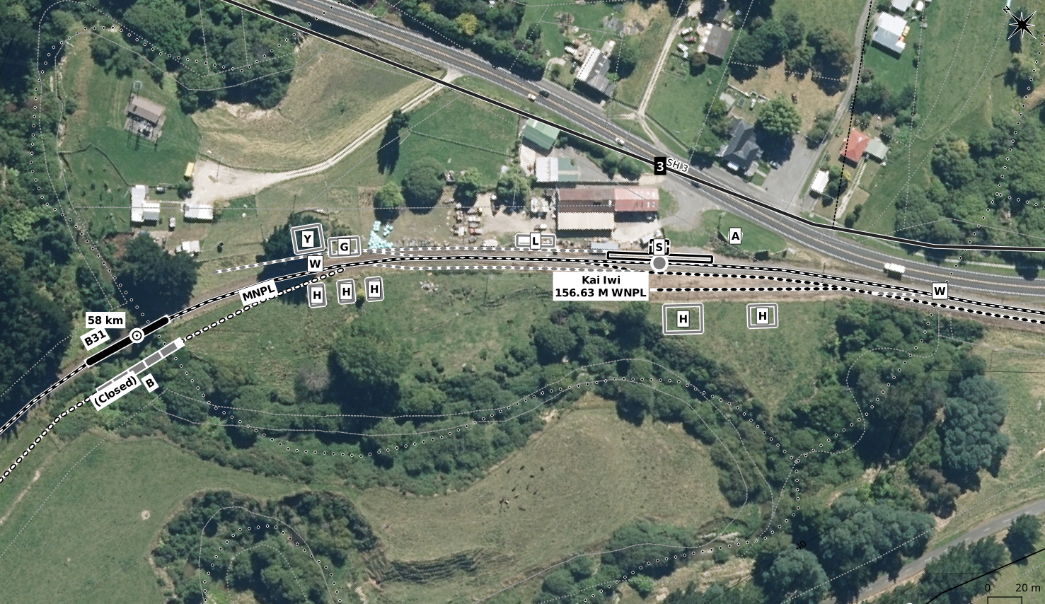
Although no Retrolens coverage is presently available, occasionally there is enough on the current aerials plus a really good Whites Aviation picture for it to be worth while to create a station layout by estimating the size and position of various features in relation to known existing ones and so I drew this diagram of what Kai Iwi used to look like. The WA coverage was from 1949 and 1955 when the station was open, and also confirms the bridge realignment just upmile of the station.


 Here we can see that Kai Iwi was a busy little station in its day, it had the usual things you'd see in a rural station, including five houses for staff. The current station building, which I assume Kiwirail has sold off, is probably concrete, a replacement for the wooden one shown in the earlier pictures which was much larger, and it still sits there on the platform. Pretty much everything else has disappeared. No idea on when the bridge was replaced. The Kai Iwi crossing loop, which appears to be, like Ruatangata, a recent addition (late 2000s) with the extension of CTC on the route, can be seen going out of the east side of the image. The siding which comes off at the west end is not part of the original station layout, so we can assume nothing was left of the original station when the present loop was installed. Prior to the extension of the CTC, only Marton-Whanganui was worked by it, with electric train tablet on other parts of the MNPL converted to track warrant, as well as automatic signalling on the SOL to track warrant. I am unsure as to how far the CTC runs on the MNPL now.

Just to add to all the existing mileage controversies, the Quail Atlas, which created one with their metric distances that vary from the ones in the Working Time Table, has in the first edition used different mileages from the ones I have used on these MNPL maps. Kai Iwi as an example is shown as being at "148.09" miles. Likewise their distance for Marton on the NIMT is shown as being "311.02" miles from Auckland, or "112.00" miles from Wellington. The respective distances from the documentation I am using (NZR W&W track mileage diagrams) puts Marton at 116 miles 28 chains from Wellington and 309 miles 37 chains from Auckland. These distances are the same as the ones in the NZRLS 1947 WTT reprint that is a secondary source for me. Hence once again where have the Quail people got their distances from. Going all the way back to Wellington the early distances are correct and the possible sources of error not at all obvious, but they just gradually creep in.

As far as I am concerned the maps will keep using the mileage sources they currently have, and the key and each PDF volume will have explanatory notes about the mileages (another issue for the maps is I have converted miles and chains into decimal miles, so that the decimal point means the same thing for both imperial and metric distances which are intermingled all throughout the maps). Where some of the Quail stuff comes from is not clear, unless they have a more recent imperial WTT as a source. The problem with changing sources is that the stations that have since closed will not appear in the newer source. This is why I am currently attempting to source a early metric era WTT to have as much metric data from a WTT as possible, and not showing any metric distances other than those which can be obtained from a WTT.

Sunday, 13 January 2019

Marton New Plymouth Line [1A]: Whanganui-Castlecliff 1

I am currently looking to bring the maps from Marton to Westmere, the first 50 km of the MNPL, to a conclusion in the next week or so. Probably these will be released as a full set of maps, along with the existing diagrams of the rest of Volume 4. But there may not be a PDF produced at this stage. I am not ruling out an interim PDF, but ideally I still need to find a 1974 era working timetable to be able to include the metric distances for as many stations as possible without reliance on the suspect Quail Atlas distances. Putting in km pegs and bridge numbers without otherwise updating is a quick solution on the existing diagrams and I may allow extra time to achieve just that. I do have all the resources needed to put in WNPL distances and those will be shown along with anything else I can get from official sources.

Here are some recent screen captures:
 Castlecliff station (the sidings have not been adjusted to fit the aerial photo, as is commonly necessary when aerial photos replace diagrams)
 A zoom out to take in the general area of Castlecliff with the various wharf sheds and sidings.
 The area of what used to be Wanganui and in the days of the separate Castlecliff railway, the Town station at the beginning of their line. The Castlecliff line was re-routed several times.
 A look at how things have changed at Aramoho in the last few years. The points used to be right at the end of the bridge, with the frog on the far side, and the road crossing being over the four closer rails. This arrangement which was put in place about thirty years ago has been abandoned around 2014 in favour of having the entire set of points located on the west side of the road. This meaning the curves are sharper but making it easier to maintain the points.
General overview of Aramoho and this one shows the fertiliser factory to the north which had its sidings, some of the track still in place at the present.
Another view of Aramoho Junction that attempts to depict the back leg of the triangle. For the vast majority of its existence this leg did not actually follow the route that I have shown, but until I can get aerial photos of Aramoho in any time frame it is not going to be possible to be totally accurate. However the above will be altered in some way.

Right now I am looking at the Castlecliff line as I do have some aerial photos from 1967 covering most of it although the detail is not too sharp but I do hope with the help from Whites Aviation as well to be able to get that sorted out next week.


Friday, 4 January 2019

Marton New Plymouth Line [0A]: Intro

I have taken a couple of side trips from the main schedule for the maps this year, for just the month of January. These two are Marton-Whanganui and the Nelson line (volumes 4 and 7 respectively). By the end of January I expect to be back at work on Volume 12 and Volume 5 being as explained previously the main priorities for map completion this year.

The part of Volume 4 that will be completed is just from Marton to Whanganui incorporating the Turakina-Okoia deviation that I recently mapped. Whanganui is covered by 0.1 metre aerial photography which is of an excellent resolution for tracing off maps. Some years ago I mapped a lot of the stuff around Whanganui city using various sources other than Retrolens and this will come in handy as officially this area has no Retrolens coverage as yet but I have been able to scrounge a small number of orthogonal photos from various sources including other historic archives that I will use to refer to and mosaic if practical.

I am not mapping any more of the MNPL than this 43 km section. Whanganui is special to me because I lived there in my childhood. But the lack of Retrolens coverage of the area means it's not worth putting much effort into at present. So I don't expect to spend too much time on this set of maps, which is good.


The first photo covers what was the East Town rail yards. Originally East Town was a little further west and this was later called Poutini Street, perhaps when this yard opened. It is now called W(h)anganui. Previously this name was held by the station at Taupo Quay next to the City Bridge (Victoria Ave) which closed many years ago. The station was then moved down to the freight depot site, which has also closed. The triangular junction at this site which used to face towards the original station along Moutoa Quay, was altered to face the other way for the new station, and these days it simply links the Castlecliff branch to the Wanganui branch to serve the sidings down there.


More of the East Town area, including the East Town Shops, the railway workshops for Wanganui. NZR used to have workshops at a number of different sites, apart from the four main centres. The shops at Wanganui closed in the 1980s, and these days nationwide there are just two sites: Hutt in Wellington, and Hillside in Dunedin, which almost closed a few years ago, but held on as a heavy lift site because of the overhead crane housed there, and is now ramping up again for construction of new rolling stock.

From East Town the MNPL carries on across the river to Aramoho and from there continues north to Westmere onwards towards New Plymouth. So Wanganui has had three railway stations. Aramoho was the main line station in the days of passenger services whereby trains or railcars generally between Wellington and New Plymouth would stop there. In fact I remember in the mid 1970s meeting a Fiat railcar there. "Standard" railcars operated the services until 1972, while Fiats continued operating until they were withdrawn in 1977, which was the end of passenger services altogether.

The second station was the one down the end of the Wanganui Branch, which is the line you can see turning southward off the bridge at Aramoho. It ran for 5 km down to the general area of the Wanganui CBD where the Wanganui station originally was, alongside the Town wharf, in the days when the main part of the port was located there. Once the port declined, this station was eventually closed and the main yards were moved further down to the triangle. Wanganui did see passenger services until 1959; the Wellington to New Plymouth services always stopped at Aramoho, with a separate service between Aramoho and Wanganui. There were also services that ran directly from Wanganui to New Plymouth, known as the Taranaki Flyer; these ceased in 1959 and that was the end of passenger services to Wanganui. The station was relocated about 1987 when the junction was turned the other way to link directly through onto the Castlecliff branch.

The line to Castlecliff was built as a private railway and was not nationalised until 1956. It runs for another 5 km roughly to various industries and the more recent location of the port. For example the Imlay Freezing Works in Heads Road, now closed, was a major user of the line, and at one stage they may have had their own jetty to load ships. The wharves at Castlecliff are still used but not served by rail as the end of the line was pulled back a kilometre or two some years ago. In 2006 it was mothballed as there were no sidings remaining in use. It was reopened in 2011 and one of the sites served was an inland port for Port of Taranaki. This operation has since been cut back as Port of Taranaki no longer has container ships calling, so the site is now privately operated for container transfer.

So that's Wanganui in a nutshell and once I get the aerial photos loaded in Qgis and an aerial photo I have of the Castlecliff line mosaiced, as well as more details of East Town drawn in, I will put some more posts up.

Wednesday, 2 January 2019

Historic Map Mileages

One of the features of NZ Rail Maps is the decision to only use Working Timetable mileages or kilometrages instead of other sources that may not be accurate. The Quail Atlas is the obvious source of distances that have been shown to be inaccurate. It would seem this is because, instead of digging up the new working timetables at the time of NZR metrication in 1974, the Quail publishers apparently performed their own metrication process, converting their mileages into the kilometre equivalent by direct conversion. The reason this differs from WTTs is that deviations and realignments would add and subtract distance and the existing pegs never get moved so the NZR / KR way of handling this is a long or short mile (or kilometre). So that is the first complication and my case of choosing the working timetable distance makes for some level of complexity because it can be in imperial measurement (miles) instead of km; so I have to put a conversion table into each published map volume.

The second complexity to be addressed is that lines changed around, in the North Island mostly. The changes in the ECMT with sections being assigned and reassigned is well known, but for the areas I am working on at the moment, the NIMT was changed around a lot too. The original NIMT started in Auckland and ran down to Marton, where it joined onto what was then the Wellington to New Plymouth line. Hence the old tunnel numbers on the NIMT started from Auckland and the ones on Wellington-Marton section started from 1 at Wellington (originally on what is now the Johnsonville Line). Bridge numbers and mileposts worked the same. So I have been working on Marton-New Plymouth maps and will shortly publish the full maps for the section from Marton to Aramoho because that is a part of what I am doing, basic full maps for every part of NZ, alongside the detailed maps that are going to be of Nelson, Napier-Gisborne and Otago Central/Kingston Line. I looked at Marton and came up with, from the old WTT, Wellington-Palmerston North being 84 miles 79 chains and Palmerston North-Marton being 28 miles 52 chains, which when you add it up and convert to decimal miles puts Marton at 113.64 miles from Wellington so that will be shown (as WNPL) alongside its metric distance of 180.25 km on the NIMT, also from Wellington. Now a straight conversion of the mileage will show a discrepancy of a mile or two and that could be because of the Tawa Flat Deviation or it could be because of the Milson Deviation and I don't really know at this time.

The difference is going to be seen with stations on the MNPL which will have an imperial distance shown for "WNPL" which is the distance from Wellington so they will run in sequence with Wellington-Marton imperial distances rather than the kilometres from Marton. And for some stations there will not be a metric distance if I can't get one from a WTT. I hope to get hold of a WTT for about 1975 sometime to be able to put in some of the now-closed stations' metric distances, otherwise I am having to use some of the other resources I have. For example the first station up from Marton is Pukepapa, 1 miles 48 chains from Marton, which works out to be 115.24 miles from Wellington and that is the mileage for WNPL that will be shown next to Pukepapa's name. But we can see it is between the 2 and 3 km pegs on the map itself. The first map I looked at didn't show it but the second one did.

Marton, showing the station and the junction and start of the MNPL, or depending on your POV, the middle of the WNPL.

 Pukepapa, first station past Marton.
It's 2008, and these are track machines near the 5 km peg. Probably a ballast regulator and tamper.
There may have been a realignment between the 5 km and 6 km pegs. Probably there was a short steep grade that was worth eliminating.

Tuesday, 1 January 2019

Project Updates 1/1/2019

Welcome to the new year. Since the last time I have been busy working on a few sidelines. Maps have been produced in two other areas in particular: a map of the closed Turakina-Okoia route of the MNPL, which was bypassed with a deviation in 1947, and starting to have a look at updates to the Nelson Section maps.

If you recall when the Nelson maps were produced around 18 months ago, they were the very first maps produced that used the contemporary Linz aerial photography as a background to a map, and also the first to draw on Retrolens resources. These changes were quite far reaching as many map styles for railway lines and features on the maps have had to be altered to make them stand out against a background of any possible colour. Most commonly this is done by adding a white outline to the existing grey or black colours that styles use. Tweaking of these styles continues to the present day of course.

It was also the first time I had used Retrolens' historical aerial photos in any measure. These images informed our knowledge in particular of the route taken south of Glenhope to nearly Murchison, as the earliest available are from the early 1940s, at a time when construction works had only been abandoned some 15 years previously, so that much of the formation work was still easy to locate. Hence the maps were able to be very detailed in locating the rail corridor of its time.

What wasn't carried out at the time was the use of aerial mosaics using original aerial photography on top of contemporary as I usually do now. As a result, station layouts such as I would draw them today were not produced. To rectify this omission, I am putting together mosaics for all the stations that I can find, and these will be incorporated into updates of the maps. There will not be overall revision of the maps as a whole, what will be done is to reissue some of the map tiles that have already been published to incorporate these layouts along with any new tiles that may be needed. This includes the Scribd published map volume for what is now Volume 7.

I have also been very pleased to discover much better aerial photography for the background for Volume 7. There is 0.1 metre resolution coverage of Nelson City and 0.3 metre coverage of Tasman District. For the ones I did 18 months ago I had to use some older Tasman District photography which turns out to have a resolution of only 1 metre which is very poor and is the lowest quality I have ever seen on LDS. But I found that for those areas I can now add some 0.3 metre stuff which for some reason wasn't able to be used last year.

I am also downloading the rest of the aerial photography needed for Volume 4. This isn't because I intend to do a lot of work on Volume 4, but because I will take every opportunity to download the aerials for every volume regardless, because I want to have a complete set of basic maps for every line in NZ that I can refer to at short notice. It may well be that every volume will have a set of basic maps produced this year so that the website has a full set of content available, but the updates to most volumes except for 5 and 12 that are going to be top priority this year, will be much more in depth and detailed. Basically with everything else there will be a quick once over just to line everything up with the aerial photos and then a set of maps will be pushed out for public use. This is in line with the previous intentions to issue maps in a new easier to navigate format, except that I intend now to revise everything first.

Apart from the above, I have also been working on Volumes 5 and 12. In Volume 5 in particular I produced a basic set of maps for Wairoa using historical imagery going back to 1942. I now need to get back to producing the  aerial tiles for every station on the route and then get on with revising the maps in general. Volume 12 work continues with production of aerial mosaics (Alexandra will be the next set revised) and drawing in stuff at Clyde.