Showing posts with label Volume 12. Show all posts

Tuesday, 10 December 2019

Closure of Taieri Gorge Railway from Pukerangi to Middlemarch proposed

The big news in rail heritage this week is that Dunedin Railways has proposed to stop running trains from Pukerangi to Middlemarch on the Taieri Gorge Railway. The decision was announced on 5th December. The next day, Dunedin City Council said they had received no prior warning of the decision and that they would require a period of public consultation before allowing the decision to go ahead.

Currently, trains between Pukerangi and Middlemarch operate, on average, about every two to three weeks, but in practice, trains are only run during the peak tourist season, so that the actual frequency during that season is higher, but operations will stop completely during the cooler period of the year. This frequency is much lower than the Taieri Gorge Limited trains to Pukerangi which are at least daily year-round and can be run more often than once a day during the busiest times. Dunedin Railways, among other reasons, has cited the low demand for the Middlemarch trains compared to the costs of maintaining the track among the reasons for stopping the Middlemarch service. This service is the only one that meets the end of the Otago Central Rail Trail, and Middlemarch is the only actual township served by the Taieri Gorge Railway as there are no other population centres west of Wingatui. Middlemarch is within the boundaries of Dunedin City and this is one of the reasons it was chosen to be the terminus of the Taieri Gorge Railway when the line was purchased from the Government in 1990.

There are many questions that need to be asked, including the commercial aspect of the decision. Dunedin Railways was effectively founded by the Otago Excursion Train Trust, a non-profit heritage operator, in partnership with Dunedin City Council. Originally they each held a 50% share of the company. However because of a requirement to inject additional capital into the company at various stages, OETT's shareholding has dwindled to 28% at the time of writing this, with Dunedin City Council (formally Dunedin City Holdings) having a majority shareholding of 72%. This implies OETT did not have the means to provide the additional capital at the time it was needed. Due to the minority ownership position that OETT are in, they do not have much ability to influence the business culture of Dunedin Railways. This leaves DCH in the position of being able to direct DRL into more of a commercial focus than perhaps some would like. The problem is that DCH is being pressured by DCC to focus on producing divendends out of its commercial holdings. Whilst we have no information to confirm specifically that DCL has pressured DRL to produce a dividend from Dunedin Railways, it remains a possibility that Dunedin Railways is being pressured to increase the financial return out of its operations.

OETT's position appears to be one of discontent about its minority shareholding position with the company. We have not had this officially confirmed, but have sighted OETT newsletters that have strongly implied this being the case. It is known that a Memorandum of Understanding between OETT and DRL took many months to negotiate before finally being confirmed relatively recently. It is also known that OETT are attempting to negotiate some sort of case that they have called a special general meeting of their members to discuss and that OETT have had difficulty in getting agreement from Dunedin Railways management on projects that they have wished to fund on the railway. But for the record, OETT have declined to comment in any shape or form about the situation relating to Dunedin Railways or anything at all to do with the Middlemarch issue.

It does appear to us that if the Railway does get closed beyond Pukerangi that the best option would be for OETT to step in and take it over, as well as the Middlemarch rail heritage precinct. The next step could be to lease the line to be operated with light vehicles for a daily operation to meet the train at Pukerangi, for people arriving or departing Middlemarch on the rail trail. We believe it is unlikely that the 18 km of line could be maintained for normal heavy rail operations and therefore light vehicles (golf carts?) would require less maintenance. This option would have the advantage of providing a daily connection that is not currently possible with the present irregular services. Some sort of special vehicle to carry bicycles would be needed.

We understand Dunedin City Council is currently consulting on the matter and everyone should take the opportunity to submit to their process. We will post more details of this as soon as we have them.

Friday, 31 May 2019

Otago Central Railway [61BB]: Alexandra-Cromwell 25: Cromwell Gorge Survey

Last time we wrote about the Cromwell Gorge section that we have been remapping. We chose to redo the aerial mosaics down this section from scratch for various reasons, but a part of that has been the discovery that the original placement of the historical photos in some places was most probably incorrect in that the alignment for the old railway was too far into the present hydro lake.

For various reasons it is extremely difficult to overlay historical aerial photos in steeply graded terrain like this gorge which has steep sides and that is primarily because of perspective distortion with terrain which is not directly below the camera lens and that is a key reason why the process called orthorectification is used by Linz and others to get aerial photos that are geometrically corrected for using in map work. We don't have that option with the old maps, so the placement is a lot of guesswork. But we have found some historical aerial photos taken between 1980 and 1992 through the Gorge and they are confirming some errors in some of the original aerial layers that were produced. A part of the issue would be with the lower resolution base layers that were used at the beginning.

Right now we are just checking with aerial photos from the late 1980s through the area to confirm the alignment and make a few readjustments where necessary to ensure the result is as good as it possibly can be. This will mean a couple more days work before having something to redo the mapping with. We did get a 1991 survey scanned for evaluation back in 2017 but didn't draw too many conclusions from it. But having reasonably good coverage of a few areas helps a lot.

Ultimately the only real way would be to have access to original survey plans or drawings that plotted the new highway route in the Gorge compared with the existing route. Maybe these exist in Archives somewhere. The issue for our maps isn't that a particular aerial photo is uncertain as to its longitudinal placement along a particular part of the Cromwell Gorge; it is mainly the question of how to align things across the width of the Gorge with limited referential viewpoints and various distortions.

We had hoped to progress this work further this week but various time commitments have prevented that. We have also been working on maps of Christchurch City this week.

Friday, 24 May 2019

Otago Central Railway [61AA]: Alexandra-Cromwell 24: Cromwell Gorge Survey

So here we have the first post on the Otago Central Railway for 2019. Last week I started redoing the Cromwell Gorge maps using the same 1962 historical survey images as previously, except this time sourced from Retrolens. They are a slightly higher quality, but the main change is harmonising everything with the other surveys by using the 0.4 metre tiles instead of the old 0.75 metres and also using the 1972 images of both Clyde and Cromwell stations which helped to fix a few issues. I have now finished off the survey and am about to produce the map tiles for use in Qgis. As a result some of the already concluded and drawn maps will need to be altered slightly as I have reached some slightly different conclusions about the position of the railway in relation to the hydro lake.

These images of Cromwell were produced last week and shared on Facebook.


Apart from the new mosaics of the section through the Gorge I am also putting all the station layouts for Omakau-Cromwell together into another Gimp project and the Cromwell and Clyde station maps will be tied into the CG maps so that everything joins together properly.

Friday, 17 May 2019

Project Diary 2019-05-17

We try to post at least once a week depending on what we are doing in this project. Most of the posts are about specific volumes or regions we are working on. Other times there will be a progress report for the whole project like there was last week. This week it will just be a diary entry because whilst we have been doing a lot of map work this week, not a lot of it has related specifically to NZRM.

This week the majority of our time has been taken up with getting a complete set of maps for Christchurch City. This meant downloading a lot of stuff from Land Information New Zealand, because they have a 3.5 GB limit for the estimated size of each download. As it happens, it is more like 5 GB actual download in a lot of cases. But it meant that at a pixel spacing of 0.075 metres, there are a LOT of layers for the whole city. It works out to something like 60 GB. If you have a few dollars you can get them to courier the data layers to you. With the fact we don't have any spare cash to spend, we just settled for splitting up the city layers into a series of downloads to get all of it. There are some overlaps which means we don't quite have the expected efficiency and because we inadvertently got some gaps between downloads we had to make some extra downloads to be able to fill in those gaps.

So we now have Christchurch City covered for 2018 (central only), 2015 (whole city), 2011 just after the quake (central only) and c.2010 (actually between 2004-2010 and for some reason the dates aren't more precise) which again is the whole city. We also have some historical retrolens layers to overlay at some point. We did consider downloading all the 2011 imagery and in fact did set up a series of downloads in Linz but haven't actually executed those downloads because that imagery is at 0.1 metre pixel spacing and while it is very good it is also just after the quakes so it does have limits. But it is a shame that there isn't high resolution imagery before then that can be downloaded. Even 0.3 metres would be better than the 0.75 metres 2004-2010 stuff.

As far as the NZRM project actually goes the work this week has been on the Otago Central line. First up is to redo the Cromwell Gorge section with the Retrolens scans of survey 1452 which are distinctly sharper than the original ones we paid for a few years ago, and then particular stations. At the moment Omakau-Cromwell is being considered as one Gimp project covering a number of stations. It is separate from the Cromwell Gorge mosaics because of differing resolutions. The Cromwell Gorge part was originally done at 0.75 metre base imagery because that was all that was available for the whole section, but in 2017 the full area became available at 0.4 metres. But initially all that we did was scale the 0.4 metres to 0.75 metres and overlay it with the 0.75 metre stuff. Now we have scaled the 0.75 metre base to 0.4 metres so as to be able to use this scale base imagery for the Gorge section.

Friday, 3 May 2019

Otago Central Railway [47J]: Current delay in OCR maps

The current effort on NZ Rail Maps to map the Otago Central Line started in November of 2017 - about 18 months ago. It was at that time with the first of the posts in series 47 that we started the widespread use of the LINZ background imagery and bringing in historical imagery with the mosaic projects. We had at that time hoped to complete the set of maps for the entire line by a series of deadlines which eventually stretched out to the end of 2018.

Since the beginning of this year we decided to temporarily set the Otago Central line aside and work on other projects. One of the reasons for this is that LGGA are still scanning the aerial images for that area and adding new stuff all the time. Rather than doing an area then finding there is new stuff and going back to add it is a good enough reason for deferring the completion of work on maps for railways in Otago.

We just recently discovered LGGA have found survey 1452 which is State Highway 8 that we have used for the Cromwell Gorge has been added so we are currently poring over that to see if their scans are better quality than what we already have. Another example is patiently waiting until finally the one and only good quality scan of Ida Valley became available which was late last year.

We don't quite know when Otago Central will be completed but it is still very much under consideration and being worked on behind the scenes from time to time.

Monday, 17 December 2018

Project development: Work programme for 2019

In my last few posts I have talked about the PNGL mapping I am working on. I have just about completed downloading the base aerial photography, and are working on mosaics for almost every station on the line. This is Volume 5 of the 12 volume map series and the PNGL and its branches is the entire content for it.

I have also been working on Volume 12 with Otago Central Railway and Kingston Branch (and its branches) maps being developed which will be the entire content of Volume 12. This of course particularly the Otago Central has been a key focus for the past couple of years.

The intention for 2019 is to complete both of these volumes more or less simultaneously which is going to be the majority of the work on the whole maps project. These two volumes when complete will add to the existing Volume 7 which was completed a year or two ago which is for the Nelson region. 

I will also republish all diagrams for all existing lines in 2019 but there is not expected to be any other volumes progressed substantially in 2019. The diagrams will be available only as images, as PDFs are only produced for completed map volumes in their entirety. But with the images being hosted on Google Photos, it will be possible to download a complete set and use them offline. All of the map resources will be accessible from the Wordpress site. At the moment not much is listed there but I will get onto it over time. Each line will have its own sub page with historical and current information about the lines / routes as well as linking to the maps covering that line.

Beyond 2019 there is currently increasing competition for my time from other interests and therefore it is difficult to predict how much work will be done on other areas of the maps or other priorities other than those listed above. The maps project will always be an interest but I expect that my current record time commitment which involves work almost every day of the week at present, will change over time to having less time available to produce. So I'm not confident the maps will continue at the same pace as they have in the last two years, beyond next year.

As I alluded to previously, Volume 12 and Volume 5 have got special treatment compared to other volumes, in being given a higher priority and having greater use of historical resources in production of the maps. Due to the lower priorities I don't expect the same treatment for the other map volumes. Every map will have base aerial photography based maps and diagrams produced, but there won't be the same level of historical imagery and station detail to be found in other volumes.

Friday, 14 December 2018

Otago Central Railway [64C]: Middlemarch-Ranfurly 3 - Ranfurly 1

Ranfurly using the 1973 aerial survey as a background. Ranfurly is a nice little railway precinct with virtually all the buildings intact except for the first goods shed and the first engine shed, and is a complete contrast to Alexandra where only the station platform remains.

At the moment I am busy downloading all the base aerial photography for Napier-Gisborne which is slowing down Volume 12 stuff a bit but it is coming together and I will be revising some more of the Central stuff over the weekend.

Wednesday, 12 December 2018

Otago Central Railway [64B]: Middlemarch-Ranfurly 2 - Waipiata 1

It's two months since I started a series for the Middlemarch to Ranfurly section of the OCR. There weren't at that stage any maps in production for the series. Since that time I have gone back and redone some of the earliest maps with new higher resolution coverage which has thrown the whole schedule back. Right now however I am quickly putting some mosaics together for a number of different stations while I am also updating all the maps as quickly as I can. So I hope to get a fair bit done over the holiday period in terms of progress on a number of the different maps and catch everything up a bit. I had spent quite a lot of time over the past week or so looking at other areas but right now it is just Central I have decided to focus on.

This map is an overview of Waipiata in 1975. Although only just south of Ranfurly, Waipiata was still open at that stage and in fact stayed open almost to the end of the line's closure in 1990, although only as a crossing station. There seems to have been a major stock yards there at the time although not today. Of the railway features you can see in the picture, what remains today is the loading bank and the left hand house. The goods shed was relocated to a site across the main road and a small part of the station building is nearby in Komako Road. A private crib made up of a refurbished wooden carriage and guards van is also in Komako Road.


Saturday, 8 December 2018

Otago Central Railway [61Z]: Alexandra-Cromwell 23 - 2nd Clyde Station 2

Last time I posted the 1972/77 aerial photos of Clyde station had some problems that needed to be fixed. It looks like the aerial images of a 1977 survey were significantly distorted, perhaps the plane that took the photos was not level. Anyone who has used a data projector knows about keystone adjustments you have to make because the lens is not exactly square on to the screen and the shape of the picture is distorted. The same thing will happen when an aerial survey is made and the plane is not level either laterally or longitudinally or maybe the camera is not mounted properly in the plane. Aerial photography generally uses a special plane with a camera mounted in the bottom of it looking straight down. There are other distortions that are caused by varying terrain height and on the modern aerial photography we get from Linz they run it through a computer program called orthorectification to mathematically correct these issues caused by different ground level heights, however the Retrolens photos are just straight scans of the original negative and not orthorectified in any way so especially on hilly terrain you will see such variations. But on what is a fairly flat part of Clyde over 1 mile there wouldn't be expected to be the amount of variation seen and which wasn't seen on the other generations of aerial photos. The result was something like 30 metres displacement in one particular area which is a lot. It took all day yesterday to find a workable solution with a different image of most of the area to the one that was first used.
Here are the two images for 1972/77. The first one is the original, and the second one is the corrected one.

Now that the 1972 series has been fixed, I found that the rail corridor on the 1962 series does not line up with 1972 series, so that also has to be adjusted.

Friday, 7 December 2018

Otago Central Railway [61Y]: Alexandra-Cromwell 22 - 2nd Clyde Station 1

So back to Volume 12, this time back to working on the Otago Central again. Having done the maps last month for the first Clyde station, now I have to get to work again on the 2nd station. The mosaic has turned out to have an issue with the section particularly relating to 1977, that has to be fixed, so that will take a part of today before I can update the maps for that area. Here are a range of views of this area - 1962, 1978, 1985 and present.


Friday, 23 November 2018

Kingston Branch [5B]: Makarewa - Lumsden 2 (Ryal Bush, Wilsons Crossing, Lochiel, Thomsons, Lady Barkly, Limehills, Ords, Centre Bush)

In the last two days the key focus has been mapping in all of the smaller stations now the big ones have been completed. Starting from Makarewa I have looked at every small station that I could get good aerial coverage of. That as it turns out was most of them but Ords and Gap Rd were exceptions as they must have been closed by the time the aerials were taken.

Here are all the maps I drew today.


Wednesday, 21 November 2018

Kingston Branch [5A]: Makarewa - Lumsden 1 (and Lumsden-Kingston)

The main achievement of the last few days has been getting the entire Kingston branch, Hedgehope branch and Mossburn branch current aerial photos assembled together so that I know where all the base imagery is for every station that I can map all along the line in all of those areas. We will have maps in some form for Ryal Bush, Wilsons Crossing, Lochiel, Thomsons, Lady Barkly, Limehills, Centre Bush, Wintons, Browns, Kings, Castle Rock, Mossburn, Pukearuhe, Benmore, Dipton, Caroline, Josephville, Lowther, Five Rivers, Eyre Creek, Parawa, Athol, Nokomai, Garston and Fairlight. That is just about every station on the Kingston branch except for one or two we couldn't get an aerial photo for when they were open. The next job is to start making mosaics for all these small stations, having mostly covered the bigger ones already. The big ones have all been done except for Mossburn, that is Kingston as mentioned in my last post, and Winton done yesterday.

Here are some of Winton (the yard only partly drawn) and Browns (the terminus of the Hedgehope Branch between 1953 and 1968 when the line was closed back to Winton). The Winton ones are 1964, 1972 and current, while the two of Browns are 1967 (not long before it closed) and current. As far as Hedgehope goes I can only show where it was five years after closure.


Tuesday, 20 November 2018

Kingston Branch [4A]: Mararoa - Kingston 1 (Kingston 1)

One of the issues of using Linz Data Service aerial layers is that they don't photograph the whole country every year. They photograph a certain amount every summer, and then there are a variety of different resolutions as well. The consequence of this is that coverage of the Kingston Branch itself, from Invercargill to Kingston, is at three different resolutions. It could have been four, but as I said last time, I chose not to use the 0.05 metre Invercargill coverage as I judged the 0.1 metre coverage was plenty sharp enough for my purposes. But there is still 0.1, 0.4 and 0.75 metre coverage. The latter is unavoidable as the 0.4 metre stuff only goes to just south of Kingston itself, meaning I have to bring in a small area at 0.75 metres because that area hasn't yet been upgraded to 0.4 metres - it's very old footage covering a range of dates from 2004 to 2011 and happens to cover all of Lake Wakatipu, Queenstown and a number of other areas. 

This same 0.75 metre coverage was what I originally used to do the Cromwell Gorge on the OCR. I then adapted all of that area to 0.4 metre coverage by loading the 0.4 metre tiles into the aerial mosaic in Gimp, scaling them up to 0.75 metres, overlapping them onto the existing tiles, and then scaling the entire image back down to 0.4 metres. It was done that way to avoid having to start from scratch and realign all of the aerial photo coverage over a 0.4 metre tile background. I didn't document that at the time so I am just going from memory as to how it got done. There was a mosaic I did where I also had to copy the layer masks from one file to another - I can't quite recall if it was that project or a completely different one. 

This one is slightly different because I haven't done any mosaicing just yet. What is happening is I have to make an overlap tile set of 0.75 metre tiles, which load into Qgis and line up with the existing 0.4 metre tiles. This means the tiles that come out will have some 0.4 metre imagery incorporated into them, so as to get the borders exactly correct. So I have to load in the overlapping 0.4 metre tiles, scale them up to 0.75 metres and then align them by eye. Then I can export my new 0.75 metre tiles out to be loaded into Qgis. Apart from adding Kingston in, one of the reasons for doing these 0.75 metre tiles is to get rid of some nasty black edges on the 0.4 metre tiles. For some reason, LDS like to produce fractional tiles, with a piece of solid black that happens to be an irregular shape filling in the rest of the tile, or else a tile that is not the full height or width. So getting rid of the black edge is another reason to make an overlap mosaic. 

As it happens, we aren't interested in producing 0.75 metre tiles as our output. We want 0.15 metre tiles to be close to the resolution of the NZR retrolens aerial photos of Kingston that are going to be overlaid onto this mosaic and output to produce our historical tiles for drawing the Kingston yard. So this is a more complex project than just overlapping a bit of imagery in to fix the edges of a map. I had to do LDS tile overlaps for several parts of the OCR maps because there were several areas, including part of the Cromwell Gorge and another area was the Manuherikia River valley between Chatto Creek and Galloway. There were two different generations of aerial photography each covering just a part of the area and they had to be overlapped, and inconveniently came complete with these black edges and irregular shaped tiles. It wasn't like I could get the whole area covered in one of the series - I had to use both series and fix these overlap issues. I scaled the 0.75 metre tiles for Kingston to 0.15 metres because it's an exact multiple, and then overlaid the Kingston historical stuff on top.

Here is Kingston in 1974 and sometime between 2004-2011.


Sunday, 18 November 2018

Kingston Branch [3A]: Makarewa - Thornbury 1 (Oporo)

For those of you who must have thought there was an avalanche of posts coming last Monday because I posted four in one day, sorry to disappoint you. That was a just a catch up on material that I had shared throughout the preceding week on Facebook. This week has been lacking posts as well, but there is only one post coming out today, as the week has been largely occupied with other things. However in this post we are starting a new series, which covers the first part of what was the Tuatapere Branch. It started at Makarewa, and along the way took in Thornbury, which was where the Wairio Branch diverged off. Since the 1980s, Makarewa-Thornbury has been incorporated into the Wairio Branch, which in more recent years has become the Ohai Line, having itself incorporated what was formerly the Ohai Railway Board line, latterly called the Ohai Industrial Line. 

I don't know how many posts will be in this series except that there aren't any more coming for a while after this one because I am prioritising finishing the rest of the Kingston Branch going north to Kingston, and its northern branches, before again turning my attention to the western branches of the Kingston Branch (Tuatapere and Wairio). And even then, progress on the Kingston Branch proper will be subject to priorities for the Otago Central Railway. This post has been convenient to do because it falls within the boundaries of the last of the high resolution LINZ aerial photos of Invercargill to Makarewa that we have been working from for the Kingston Branch itself up to now. When I did this section I had two choices: I could have used 0.1 metre imagery or 0.05 metre imagery. Both of them got downloaded to my computer, but on discovering that the 0.1 metre stuff covered a much larger area, as far north as Makarewa, that is what I chose to use. As it happens, there is a small part of the west line as far as Oporo that is also included.

In looking at retrolens photography it was soon possible to discover that there was a ballast pit with its own siding clearly visible and in operation in an aerial photo taken in 1956 so this is the subject of today's post. The first two photos are the Oporo station with its sidings, and the second pair are the ballast pit and its siding. There is remarkably little to be seen today of the ballast pit and station site, and even four bridges have been eliminated in the short section of the route between the river and the station.


Monday, 12 November 2018

Kingston Branch [2F]: Makarewa-Lumsden, Mararoa-Kingston. Mossburn, Hedgehope, Tuatapere, Wairio

So now that I have mapped Invercargill-Makarewa and Lumsden-Mararoa on the Kingston Branch, work will be continuing to map, firstly, the rest of the Kingston Branch, followed by the Mossburn Branch, Hedgehope Branch, Tuatapere Branch, Orawia Branch, Wairio Branch and Ohai Railway Board section. This will proceed at a slower pace than previously on the KB as I am going to continue with the Otago Central Railway as well.

Aerial coverage north of Makarewa for the Kingston Branch varies with some areas well covered and others not. Some areas are covered by various surveys, notably one from 1964, and some from 1938 to 1946 of lesser quality that mean I can get coverage of most of the way from Makarewa to Lumsden, particularly with the official NZR survey of Winton, and on the Hedgehope branch there is also good quality coverage of Browns when it was still open. North of Lumsden there is good quality coverage of most of the stations to Athol, plus the NZR survey of Kingston has showed up. This is really quite a good situation overall for a rural line because many of them don't have any high resolution coverage at all. The Mossburn Branch is also well covered. I haven't investigated the entire length of the Tuatapere or Wairio lines yet but major stations have the NZR surveys.

So work on that will be starting soon but the timeframe is going to be a bit more disjointed as it depends on what I am working on for Otago Central. In other words all of Volume 12 is being worked on to completion, at which point I can look at putting together a PDF for Volume 12 as well as all of the online maps.

The web site has had the latest revision of the map keys (no. 52) added to it which is current as of yesterday. As usual, older maps will be updated to the new specification in their next revision.

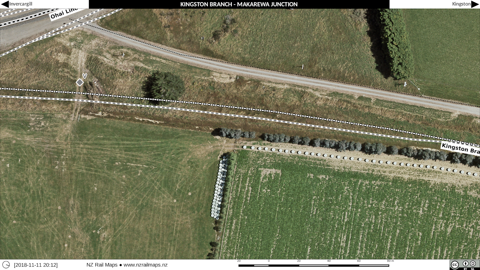
Kingston Branch [2E]: Invercargill-Makarewa 5 (Makarewa 1)

Makarewa (12.12 km) was an important station on the Kingston Branch (Ohai Line) because it used to be a junction. This was where the Tuatapere Branch started off the Kingston Branch. But since the last part of the Tuatapere Branch from Thornbury to Riverton closed in 1978, Makarewa to Thornbury was incorporated into the Wairio Branch, and since the last part of the Kingston Branch from Makarewa to Mararoa (along with the Mossburn Branch from Mararoa to Mossburn) closed in 1982, Invercargill to Mararoa was also incorporated into the Wairio Branch, which is now called the Ohai Line.

Since metrication occurred before the closure of the Tuatapere Branch and since it is likely that branch was metricated (the working timetable of 1974 would show this but I don't as yet have that available for reference for lines in Southland), km pegs for this line were probably just renumbered when it was put into the Wairio Branch. As Makarewa was just past the 12 km peg, it was probably easy to just renumber the existing km posts from Makarewa to Thornbury rather than re-measure all the distances. This is of course speculation but we don't have many Way and Works records available for research as they tended to have been discarded when the various offices closed up - there are few chainage books for example. It was a real gift to have chainage books for the Otago Central Railway and these actually got into Archives New Zealand via private collections rather than being transferred from NZR.

The reason for me to say this is that mileposts or km posts are really just a namespace because it is not routine to remeasure when a distance changes in a line and so there end up being short or long miles (or km) and so it seems likely the existing pegs in the Tuatapere and Wairio branches just had new numbers put on them when the Wairio Branch took in pieces of the Tuatapere and Kingston branches to become the name of the entire route from Invercargill to Wairio, which we assume occurred possibly starting in 1978 and continuing through 1982.
 
The other notable thing about Makarewa is the old freezing works which is right beside the western side of the Ohai Line as the line curves around to head west. This was originally quite a major plant and even had accommodation and recreational facilities for people that worked there. There was an accommodation block probably for single employees as well as a lot of housing on the opposite side of the main road, a bowling green is also visible on the older aerials. All this stuff as well as many plant buildings are gone now and the railway sidings are no longer in use. 

Makarewa was an island platform (the platform and station building are gone) and also had a bridge to the south across the Makarewa River (Bridge 6) that is still partly decked (it was formerly decked both sides) because shunters would have to be able to walk across the bridge when shunting through the mainline points at the south end. 

Maps are from 1972 and 2015.